
Spenden
Topografische Karte Mataasnakahoy
Klicken Sie auf die Karte, um die Höhe anzuzeigen.
Spenden
Mataasnakahoy
It has 16 barangays and its total land area is 22.10 square kilometres (8.53 sq mi). It is bounded by Balete and Lipa City with Taal Lake on its western edge. The town is known for its cool climate due to its high elevation of 379 metres (1,243 ft).
Spenden
Über diese Karte
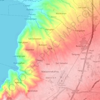
Name: Topografische Karte Mataasnakahoy, Höhe, Relief.
Ort: Mataasnakahoy, Batangas, Calabarzon, 4223, Philippines (13.94909 121.01296 14.01149 121.12500)
Durchschnittliche Höhe: 216 m
Minimale Höhe: -7 m
Maximale Höhe: 573 m
Spenden
Andere topografische Karten
Klicken Sie auf eine Karte, um ihre Topografie, ihre Höhe und ihr Relief anzuzeigen.
Spenden
Spenden
Spenden
Spenden
Spenden
Spenden
Soro-soro Ibaba RWSA
Philippines > Batangas > Batangas City > Sorosoro Ibaba
Durchschnittliche Höhe: 113 m
Spenden
Spenden
Spenden
Spenden
Spenden
Spenden
Spenden
Spenden
Spenden
Spenden
Spenden
Spenden
Taal Volcano
Philippines > Batangas > San Nicolas
Volcano Island sank from 1 to 3 m (3 to 10 ft) as a result of the eruption. It was also found that the southern shore of Lake Taal sank in elevation from the eruption. No evidences of lava could be discovered anywhere, nor have geologists been able to trace any visible records of a lava flow having occurred at…
Durchschnittliche Höhe: 91 m
Batangas City
Philippines > Batangas > Batangas City > Batangas City
The city is the center of the radio listening market in Batangas, and is served by local radio stations, as well as some radio stations from Lipa and other parts of the Mega Manila area. The Roman Catholic Archdiocese of Lipa, through the Radyo Bayanihan System, hosts two local radio stations: ALFM 95.9 Radyo…
Durchschnittliche Höhe: 108 m
Spenden
Spenden
Spenden
Spenden
Spenden
Spenden
Spenden