
Vielen Dank für die Unterstützung dieser Website ❤️
Spenden
Spenden
Topografische Karte Dharashiv
Klicken Sie auf die Karte, um die Höhe anzuzeigen.
Vielen Dank für die Unterstützung dieser Website ❤️
Spenden
Spenden
Dharashiv
The city of Osmanabad has an elevation of 653 metres (2,142 ft). Osmanabad is located in the west-central part of Osmanabad Tahsil. Nearby towns include Tuljapur, Bhoom, Paranda, Washi, and Kalamb. Solapur, located southwest of Osmanabad in Solapur district, is the nearest sizeable city. Osmanabad is on the Balaghat Pathar. The Bhogavati River flows through the city and meets the Sina River near Mohol in the Solapur district.
Vielen Dank für die Unterstützung dieser Website ❤️
Spenden
Spenden
Über diese Karte
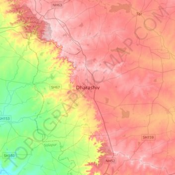
Name: Topografische Karte Dharashiv, Höhe, Relief.
Ort: Dharashiv, Dharashiv District, Maharashtra, 413500, India (18.02536 75.88203 18.34536 76.20203)
Durchschnittliche Höhe: 619 m
Minimale Höhe: 487 m
Maximale Höhe: 719 m
Vielen Dank für die Unterstützung dieser Website ❤️
Spenden
Spenden