
Spenden
Topografische Karte Taha’a
Klicken Sie auf die Karte, um die Höhe anzuzeigen.
Spenden
Über diese Karte
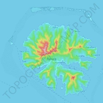
Name: Topografische Karte Taha’a, Höhe, Relief.
Ort: Taha’a, Leeward Islands, French Polynesia, 98733, France (-16.68462 -151.56933 -16.55486 -151.41190)
Durchschnittliche Höhe: 36 m
Minimale Höhe: -1 m
Maximale Höhe: 558 m
Spenden
Andere topografische Karten
Klicken Sie auf eine Karte, um ihre Topografie, ihre Höhe und ihr Relief anzuzeigen.
Mont Orohena
France > French Polynesia > Windward Islands > Māhina
Mont Orohena is a mountain located in the South Pacific, on the island of Tahiti. With an elevation of 2,241 metres (7,352 ft) above sea level, it is the highest point of French Polynesia. Mont Orohena is an extinct volcano and ranks 7th in the world for topographic isolation.
Durchschnittliche Höhe: 1.282 m
Spenden
Spenden
Spenden
Spenden
Spenden
Spenden
Spenden
Spenden
Fatu Huku
France > French Polynesia > Marquesas Islands > Hiva Oa
The island is essentially a huge rock, looming steep-sided out of the ocean and rising to a flattened plateau with a maximum elevation of 361 metres (1,184 ft). Fatu Huku is the youngest of the volcanic Marquesas Islands, estimated to be only 1.3 million years old which accounts, in part, for its ruggedness as…
Durchschnittliche Höhe: 8 m
Spenden
Spenden
Spenden
Spenden
Spenden