

Topografische Karte Air Force Academy
Klicken Sie auf die Karte, um die Höhe anzuzeigen.
Air Force Academy
The campus of the academy covers 18,455 acres (29 sq mi; 75 km2) on the east side of the Rampart Range of the Rocky Mountains, just north of Colorado Springs. Its elevation is normally given as 7,258 feet (2,212 m) above sea level, which is at the cadet area. The academy was designed by Skidmore, Owings and Merrill (SOM) and lead architect Walter Netsch. SOM partner John O. Merrill moved from Chicago to a Colorado Springs field office to oversee the construction and to act as a spokesman for the project.
Über diese Karte
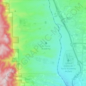
Name: Topografische Karte Air Force Academy, Höhe, Relief.
Durchschnittliche Höhe: 2.158 m
Minimale Höhe: 1.924 m
Maximale Höhe: 2.878 m
Andere topografische Karten
Klicken Sie auf eine Karte, um ihre Topografie, ihre Höhe und ihr Relief anzuzeigen.
Stratton Meadows
United States > Colorado > El Paso County > Colorado Springs
Durchschnittliche Höhe: 1.819 m
Garden of the Gods
United States > Colorado > El Paso County > Colorado Springs
Durchschnittliche Höhe: 1.970 m