
Topografische Karte Lochcarron
Interaktive Karte
Klicken Sie auf die Karte, um die Höhe anzuzeigen.
Über diese Karte
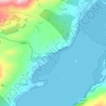
Name: Topografische Karte Lochcarron, Höhe, Relief.
Ort: Lochcarron, Highland, Scotland, IV54 8YD, United Kingdom (57.38010 -5.51302 57.42010 -5.47302)
Durchschnittliche Höhe: 67 m
Minimale Höhe: -1 m
Maximale Höhe: 405 m
Andere topografische Karten
Klicken Sie auf eine Karte, um ihre Topografie, ihre Höhe und ihr Relief anzuzeigen.
Glencoe
United Kingdom > Scotland > Highland
Glencoe, Highland, Scotland, PH49 4HS, United Kingdom
Durchschnittliche Höhe: 114 m
Fort William
United Kingdom > Scotland > Highland
Fort William, Highland, Scotland, PH33 6AQ, United Kingdom
Durchschnittliche Höhe: 122 m
Inverness
United Kingdom > Scotland > Highland
Inverness, Highland, Scotland, IV1 1PQ, United Kingdom
Durchschnittliche Höhe: 163 m
Ben Nevis
United Kingdom > Scotland > Highland
Ben Nevis, Highland, Scotland, United Kingdom
Durchschnittliche Höhe: 912 m