
Topografische Karte Bremen
Interaktive Karte
Klicken Sie auf die Karte, um die Höhe anzuzeigen.
Über diese Karte
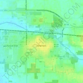
Name: Topografische Karte Bremen, Höhe, Relief.
Ort: Bremen, Marshall County, Indiana, 46506, United States (41.43555 -86.17469 41.46063 -86.13028)
Durchschnittliche Höhe: 252 m
Minimale Höhe: 243 m
Maximale Höhe: 263 m
Bremen is located in northeastern Marshall County at 41°26′50″N 86°08′58″W / 41.447109°N 86.149342°W / 41.447109; -86.149342. It is at an elevation of 854 feet (260 m).
Andere topografische Karten
Klicken Sie auf eine Karte, um ihre Topografie, ihre Höhe und ihr Relief anzuzeigen.
Plymouth
United States > Indiana > Marshall County
Plymouth, Marshall County, Indiana, 46563, United States
Durchschnittliche Höhe: 247 m
Bourbon
United States > Indiana > Marshall County
Bourbon, Marshall County, Indiana, United States
Durchschnittliche Höhe: 256 m
Culver
United States > Indiana > Marshall County
Culver, Marshall County, Indiana, 46511, United States
Durchschnittliche Höhe: 230 m