
Topografische Karte Baldwin City
Interaktive Karte
Klicken Sie auf die Karte, um die Höhe anzuzeigen.
Über diese Karte
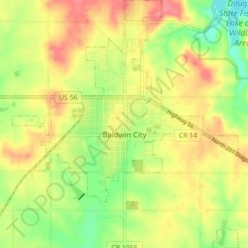
Name: Topografische Karte Baldwin City, Höhe, Relief.
Ort: Baldwin City, Douglas County, Kansas, United States (38.75298 -95.21429 38.80099 -95.15812)
Durchschnittliche Höhe: 323 m
Minimale Höhe: 286 m
Maximale Höhe: 355 m
Andere topografische Karten
Klicken Sie auf eine Karte, um ihre Topografie, ihre Höhe und ihr Relief anzuzeigen.
Lawrence
United States > Kansas > Douglas County
Lawrence, Douglas County, Kansas, United States
Durchschnittliche Höhe: 265 m
Lecompton
United States > Kansas > Douglas County
Lecompton, Douglas County, Kansas, United States
Durchschnittliche Höhe: 281 m
Lawrence
United States > Kansas > Douglas County > Lawrence
Lawrence, Douglas County, Kansas, 66044, United States
Durchschnittliche Höhe: 283 m
Eudora
United States > Kansas > Douglas County > Eudora > Eudora
Eudora, Douglas County, Kansas, 66025, United States
Durchschnittliche Höhe: 258 m
Overlook Park
United States > Kansas > Douglas County
Overlook Park, Kanwaka Township, Douglas County, Kansas, United States
Durchschnittliche Höhe: 281 m
Burcham Park
United States > Kansas > Douglas County > Lawrence
Burcham Park, Lawrence, Douglas County, Kansas, 66044, United States
Durchschnittliche Höhe: 260 m