
Topografische Karte Xhierfomont
Interaktive Karte
Klicken Sie auf die Karte, um die Höhe anzuzeigen.
Über diese Karte
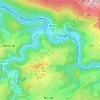
Name: Topografische Karte Xhierfomont, Höhe, Relief.
Ort: Xhierfomont, Stoumont, Verviers, Liège, Wallonie, 4987, Belgique (50.38493 5.75930 50.42493 5.79930)
Durchschnittliche Höhe: 295 m
Minimale Höhe: 178 m
Maximale Höhe: 538 m
Andere topografische Karten
Klicken Sie auf eine Karte, um ihre Topografie, ihre Höhe und ihr Relief anzuzeigen.
Borgoumont
Belgique > Liège > Verviers > Stoumont
Borgoumont, Stoumont, Verviers, Liège, Wallonie, 4987, Belgique
Durchschnittliche Höhe: 398 m
Château de Froidcourt
Belgique > Liège > Verviers > Stoumont
Château de Froidcourt, 8, Froidcour, Stoumont, Verviers, Liège, Wallonie, 4987, Belgique
Durchschnittliche Höhe: 317 m
Grimbiémont
Belgique > Liège > Verviers > Stoumont
Grimbiémont, Stoumont, Verviers, Liège, Wallonie, 4987, Belgique
Durchschnittliche Höhe: 345 m