
Topografische Karte Johannesburg Ward 106
Interaktive Karte
Klicken Sie auf die Karte, um die Höhe anzuzeigen.
Über diese Karte
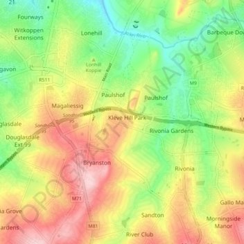
Name: Topografische Karte Johannesburg Ward 106, Höhe, Relief.
Durchschnittliche Höhe: 1.473 m
Minimale Höhe: 1.372 m
Maximale Höhe: 1.587 m
Andere topografische Karten
Klicken Sie auf eine Karte, um ihre Topografie, ihre Höhe und ihr Relief anzuzeigen.
Jukskei River
Jukskei River, Sandton, City of Johannesburg Metropolitan Municipality, Gauteng, 1610, RSA
Durchschnittliche Höhe: 1.592 m
Jukskei River
Jukskei River, Sandton, City of Johannesburg Metropolitan Municipality, Gauteng, 1620, RSA
Durchschnittliche Höhe: 1.568 m
Johannesburg Ward 74
Johannesburg Ward 74, Sandton, City of Johannesburg Metropolitan Municipality, Gauteng, RSA
Durchschnittliche Höhe: 1.638 m
Johannesburg Ward 102
Johannesburg Ward 102, Sandton, City of Johannesburg Metropolitan Municipality, Gauteng, 2125, RSA
Durchschnittliche Höhe: 1.542 m
Johannesburg Ward 112
Johannesburg Ward 112, Sandton, City of Johannesburg Metropolitan Municipality, Gauteng, RSA
Durchschnittliche Höhe: 1.519 m