Geolokalisieren
👉 Easily get elevation data in JSON, GeoTIFF and KML formats using Elevation API
Vielen Dank für die Unterstützung dieser Website ❤️
Spenden

Topografische Karte Calanasan

Klicken Sie auf die Karte, um die Höhe anzuzeigen.

👉 Easily get elevation data in JSON, GeoTIFF and KML formats using Elevation API
Vielen Dank für die Unterstützung dieser Website ❤️
Spenden

Calanasan

The town's topography or slope is predominantly rugged and mountainous with sporadic flood plains and plateaus. The municipality cradles the larger part of the Apayao-Abulog watershed area as the main source of streams that fills the mighty river which originates from the municipality.

Wikipedia (CC-BY-SA 3.0)

👉 Easily get elevation data in JSON, GeoTIFF and KML formats using Elevation API
Vielen Dank für die Unterstützung dieser Website ❤️
Spenden

Über diese Karte

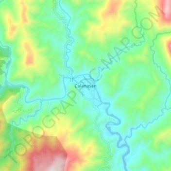
Name: Topografische Karte Calanasan, Höhe, Relief.

Ort: Calanasan, Apayao, Cordillera Administrative Region, 3814, Philippines (18.21511 121.00349 18.29511 121.08349)

Durchschnittliche Höhe: 524 m

Minimale Höhe: 246 m

Maximale Höhe: 1.172 m

👉 Easily get elevation data in JSON, GeoTIFF and KML formats using Elevation API
Vielen Dank für die Unterstützung dieser Website ❤️
Spenden

Andere topografische Karten

Klicken Sie auf eine Karte, um ihre Topografie, ihre Höhe und ihr Relief anzuzeigen.

Abulug River

Philippines > Apayao

Durchschnittliche Höhe: 77 m

Conner

Philippines > Apayao

Durchschnittliche Höhe: 411 m

Pudtol

Philippines > Apayao

Durchschnittliche Höhe: 209 m

Luna

Philippines > Apayao

Durchschnittliche Höhe: 86 m

Vielen Dank für die Unterstützung dieser Website ❤️
Spenden