
Spenden
Topografische Karte Brompton-on-Swale
Klicken Sie auf die Karte, um die Höhe anzuzeigen.
Spenden
Über diese Karte
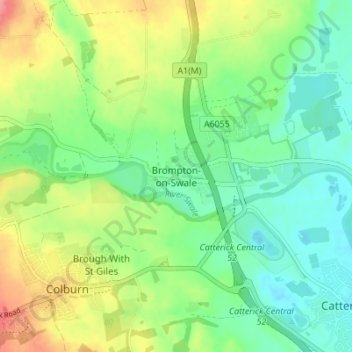
Name: Topografische Karte Brompton-on-Swale, Höhe, Relief.
Durchschnittliche Höhe: 78 m
Minimale Höhe: 49 m
Maximale Höhe: 129 m
Spenden
Andere topografische Karten
Klicken Sie auf eine Karte, um ihre Topografie, ihre Höhe und ihr Relief anzuzeigen.
Spenden
Malton
United Kingdom > England > North Yorkshire
As with the rest of the British Isles and Yorkshire, Malton possesses a maritime climate with cool summers and mild winters. The nearest Met Office weather station for which records are available is High Mowthorpe, about 6 miles (10 km) east of the town centre. Due to its lower elevation, the town centre is…
Durchschnittliche Höhe: 28 m
Spenden
Valley of Desolation
United Kingdom > England > North Yorkshire > Barden
Durchschnittliche Höhe: 258 m
Spenden
Spenden
Spenden
Craven
United Kingdom > England > North Yorkshire
Vegetation in the Pennines is adapted to subarctic climates, but altitude and acidity are also factors. For example, on Sutton Moor the millstone grit's topsoil below 275 m (902 ft) has a soil ph that is almost neutral, ph 6 to 7, and so grows good grazing. However, above 275 m (902 ft) it is acidic, ph 2 to…
Durchschnittliche Höhe: 294 m
Spenden
Howe
United Kingdom > England > North Yorkshire > Hambleton > Skipton on Swale > Howe
Durchschnittliche Höhe: 28 m
Exelby, Leeming and Londonderry
United Kingdom > England > North Yorkshire > Hambleton
Durchschnittliche Höhe: 35 m
Great Ayton
United Kingdom > England > North Yorkshire > Hambleton > Great Ayton
Durchschnittliche Höhe: 119 m
Spenden
Thornton-on-the-Hill
United Kingdom > England > North Yorkshire > Hambleton
Durchschnittliche Höhe: 80 m
Milby Cut
United Kingdom > England > North Yorkshire > Harrogate > Aldborough > Milby
Durchschnittliche Höhe: 20 m
Spenden