
Topografische Karte Bangued
Klicken Sie auf die Karte, um die Höhe anzuzeigen.
Bangued
According to the Philippine Statistics Authority, the municipality has a land area of 105.70 square kilometres (40.81 sq mi) constituting 2.54% of the 4,165.25-square-kilometre- (1,608.21 sq mi) total area of Abra. The town is generally mountainous from north to south; however, it is flat and rolling at the midsection. From here it has an elevation of 30 metres (98 ft) above mean sea level. In the north, which consists mostly of mountains, elevation ranges from 60 to 1,036 metres (197 to 3,399 ft). In the south, which is interspersed with mountain and hills, elevation ranges from 45 to 300 metres (148 to 984 ft). One such hill is Cassamata Hill which was declared a national park.
Über diese Karte
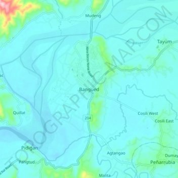
Name: Topografische Karte Bangued, Höhe, Relief.
Durchschnittliche Höhe: 51 m
Minimale Höhe: 24 m
Maximale Höhe: 298 m
Andere topografische Karten
Klicken Sie auf eine Karte, um ihre Topografie, ihre Höhe und ihr Relief anzuzeigen.
Bangued
According to the Philippine Statistics Authority, the municipality has a land area of 105.70 square kilometres (40.81 sq mi) constituting 2.54% of the 4,165.25-square-kilometre- (1,608.21 sq mi) total area of Abra. The town is generally mountainous from north to south; however, it is flat and rolling at the…
Durchschnittliche Höhe: 202 m