
Topografische Karte Mount Somers
Interaktive Karte
Klicken Sie auf die Karte, um die Höhe anzuzeigen.
Über diese Karte
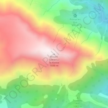
Name: Topografische Karte Mount Somers, Höhe, Relief.
Ort: Mount Somers, Ashburton District, Canterbury, New Zealand (-43.61958 171.37513 -43.61948 171.37523)
Durchschnittliche Höhe: 1.221 m
Minimale Höhe: 760 m
Maximale Höhe: 1.692 m
Andere topografische Karten
Klicken Sie auf eine Karte, um ihre Topografie, ihre Höhe und ihr Relief anzuzeigen.
Ōtūroto / Lake Heron
New Zealand > Canterbury > Ashburton District
Ōtūroto / Lake Heron, Ashburton District, Canterbury, New Zealand
Durchschnittliche Höhe: 750 m
Ashburton
New Zealand > Canterbury > Ashburton District
Ashburton, Ashburton District, Canterbury, 7700, New Zealand
Durchschnittliche Höhe: 99 m
Totara Peak
New Zealand > Canterbury > Ashburton District
Totara Peak, Ashburton District, Canterbury, New Zealand
Durchschnittliche Höhe: 1.645 m
Rakaia Gorge lookout
New Zealand > Canterbury > Ashburton District
Rakaia Gorge lookout, Arundel Rakaia Gorge Road, Ashburton District, Canterbury, New Zealand
Durchschnittliche Höhe: 358 m
Dromore
New Zealand > Canterbury > Ashburton District
Dromore, Ashburton District, Canterbury, 7772, New Zealand
Durchschnittliche Höhe: 123 m
Methven
New Zealand > Canterbury > Ashburton District
Methven, Ashburton District, Canterbury, 7730, New Zealand
Durchschnittliche Höhe: 322 m
Hackthorne
New Zealand > Canterbury > Ashburton District
Hackthorne, Ashburton District, Canterbury, New Zealand
Durchschnittliche Höhe: 199 m
Mayfield
New Zealand > Canterbury > Ashburton District
Mayfield, Ashburton District, Canterbury, 7778, New Zealand
Durchschnittliche Höhe: 266 m
Ashburton Lakes
New Zealand > Canterbury > Ashburton District
Ashburton Lakes, Ashburton District, Canterbury, New Zealand
Durchschnittliche Höhe: 645 m
Ruapuna
New Zealand > Canterbury > Ashburton District
Ruapuna, Ashburton District, Canterbury, New Zealand
Durchschnittliche Höhe: 302 m
Lake Clearwater
New Zealand > Canterbury > Ashburton District
Lake Clearwater, Ashburton District, Canterbury, New Zealand
Durchschnittliche Höhe: 751 m