
Topografische Karte Rockport
Klicken Sie auf die Karte, um die Höhe anzuzeigen.
Rockport
The topography of Rockport, Texas, is defined by its flat, coastal terrain, with the city's average elevation being around 20 feet above sea level. The land is largely shaped by the proximity to the Gulf of Mexico, which influences the area's low-lying nature, including some areas below sea level. The surrounding region is characterized by shallow waters, estuaries, and salt marshes, providing rich wildlife habitats. This coastal setting contributes to Rockport's scenic beaches and its status as a popular tourist destination, offering views of the water and nearby islands.
Über diese Karte
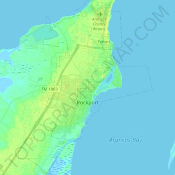
Name: Topografische Karte Rockport, Höhe, Relief.
Ort: Rockport, Aransas County, Texas, United States (27.96631 -97.11330 28.09711 -96.99953)
Durchschnittliche Höhe: 3 m
Minimale Höhe: -2 m
Maximale Höhe: 14 m
Andere topografische Karten
Klicken Sie auf eine Karte, um ihre Topografie, ihre Höhe und ihr Relief anzuzeigen.