
Topografische Karte Raleigh
Interaktive Karte
Klicken Sie auf die Karte, um die Höhe anzuzeigen.
Über diese Karte
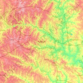
Name: Topografische Karte Raleigh, Höhe, Relief.
Durchschnittliche Höhe: 103 m
Minimale Höhe: 27 m
Maximale Höhe: 167 m
Raleigh is located in the northeast central region of North Carolina, where the Piedmont and Atlantic Coastal Plain regions meet. This area is known as the "fall line" because it marks the elevation inland at which waterfalls begin to appear in creeks and rivers. As a result, most of Raleigh features gently rolling hills that slope eastward toward the state's flat coastal plain. Its central Piedmont location situates Raleigh about two hours west of Atlantic Beach, North Carolina, by car and four hours east of the Great Smoky Mountains. The city is 172 miles (277 km) south of Richmond, Virginia, 278 miles (447 km) south of Washington, D.C., and 167 miles (269 km) northeast of Charlotte, North Carolina. A small portion of the city is located in Durham County.
Andere topografische Karten
Klicken Sie auf eine Karte, um ihre Topografie, ihre Höhe und ihr Relief anzuzeigen.
Neuse Crossroads
United States of America > North Carolina > Raleigh > Neuse Crossroads
Neuse Crossroads, Raleigh, Wake County, North Carolina, 27616, United States of America
Durchschnittliche Höhe: 75 m