
Spenden
Topografische Karte Mount Helen
Klicken Sie auf die Karte, um die Höhe anzuzeigen.
Spenden
Über diese Karte
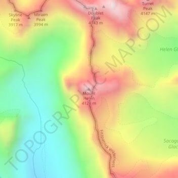
Name: Topografische Karte Mount Helen, Höhe, Relief.
Ort: Mount Helen, Sublette County, Wyoming, United States (43.15101 -109.63103 43.15111 -109.63093)
Durchschnittliche Höhe: 3.681 m
Minimale Höhe: 3.248 m
Maximale Höhe: 4.177 m
Spenden
Andere topografische Karten
Klicken Sie auf eine Karte, um ihre Topografie, ihre Höhe und ihr Relief anzuzeigen.
Pinedale
United States > Wyoming > Sublette County
Pinedale is located at 42°51′58″N 109°51′53″W / 42.86611°N 109.86472°W / 42.86611; -109.86472 (42.866162, −109.864622) and sits at an elevation of 7,175 feet above sea level. According to the United States Census Bureau, the town has a total area of 2.15 square miles (5.57 km2), all land.
Durchschnittliche Höhe: 2.196 m
Spenden
Pinedale
United States > Wyoming > Sublette County
Pinedale is located at 42°51′58″N 109°51′53″W / 42.86611°N 109.86472°W / 42.86611; -109.86472 (42.866162, −109.864622) and sits at an elevation of 7,175 feet above sea level. According to the United States Census Bureau, the town has a total area of 2.15 square miles (5.57 km2), all land.
Durchschnittliche Höhe: 2.196 m
Pinedale
United States > Wyoming > Sublette County
Pinedale is located at 42°51′58″N 109°51′53″W / 42.86611°N 109.86472°W / 42.86611; -109.86472 (42.866162, −109.864622)[8] and sits at an elevation of 7,175 feet above sea level. According to the United States Census Bureau, the town has a total area of 2.15 square miles (5.57 km2), all land.[9]
Durchschnittliche Höhe: 2.196 m