
Topografische Karte Farmington
Interaktive Karte
Klicken Sie auf die Karte, um die Höhe anzuzeigen.
Über diese Karte
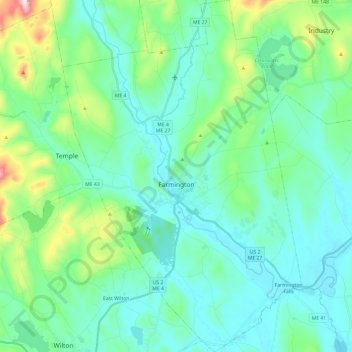
Name: Topografische Karte Farmington, Höhe, Relief.
Ort: Farmington, Franklin County, Maine, United States (44.58983 -70.22936 44.76036 -70.06578)
Durchschnittliche Höhe: 192 m
Minimale Höhe: 93 m
Maximale Höhe: 620 m
Andere topografische Karten
Klicken Sie auf eine Karte, um ihre Topografie, ihre Höhe und ihr Relief anzuzeigen.
Madrid Township
United States > Maine > Franklin County
Madrid Township, Franklin County, Maine, United States
Durchschnittliche Höhe: 522 m
Stratton
United States > Maine > Franklin County
Stratton, Franklin County, Maine, 04982, United States
Durchschnittliche Höhe: 374 m
Coburn Gore
United States > Maine > Franklin County
Coburn Gore, Franklin County, Maine, United States
Durchschnittliche Höhe: 467 m
Strong
United States > Maine > Franklin County
Strong, Franklin County, Maine, 04983, United States
Durchschnittliche Höhe: 260 m
New Vineyard
United States > Maine > Franklin County
New Vineyard, Franklin County, Maine, 04956, United States
Durchschnittliche Höhe: 251 m
Eustis
United States > Maine > Franklin County
Eustis, Franklin County, Maine, United States
Durchschnittliche Höhe: 413 m
Phillips
United States > Maine > Franklin County
Phillips, Franklin County, Maine, 04966, United States
Durchschnittliche Höhe: 322 m
Rangeley
United States > Maine > Franklin County
Rangeley, Franklin County, Maine, United States
Durchschnittliche Höhe: 548 m