
Topografische Karte Menorca
Klicken Sie auf die Karte, um die Höhe anzuzeigen.
Über diese Karte
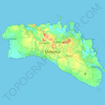
Name: Topografische Karte Menorca, Höhe, Relief.
Ort: Menorca, Balearic Islands, Spain (39.79915 3.79085 40.09459 4.32803)
Durchschnittliche Höhe: 22 m
Minimale Höhe: -2 m
Maximale Höhe: 337 m
Andere topografische Karten
Klicken Sie auf eine Karte, um ihre Topografie, ihre Höhe und ihr Relief anzuzeigen.
Puig Major
Spain > Balearic Islands > Serra de Tramuntana > Escorca
Puig Major is the highest peak on the Spanish island of Majorca. With an elevation of 1,436 m (4,711 ft) above sea level. It is situated in the Serra de Tramuntana mountains. As the mountain is located in a military zone, the neighbouring peak Puig de Massanella (1,364 m) is considered the highest accessible…
Durchschnittliche Höhe: 949 m
Serra de Tramuntana
Spain > Balearic Islands > Serra de Tramuntana
The climate in the Tramuntana Range is significantly wetter than the rest of the island, recording as much as 1507 mm (59.3 inches) of precipitation per year, in comparison with some other parts of the island where annual rainfall is less than 400mm (15 inch). It is also cooler due to the altitude, and a few…
Durchschnittliche Höhe: 175 m
Paseo Marítimo de la Bahia de Sant Antoni de Portmany
Spain > Balearic Islands > Ibiza > Sant Antoni de Portmany
Durchschnittliche Höhe: 11 m
Cova des Pas de Vallgornera
Spain > Balearic Islands > Migjorn > Llucmajor
Durchschnittliche Höhe: 24 m
Serra de Tramuntana
Spain > Balearic Islands > Serra de Tramuntana
The climate in the Tramuntana Range is significantly wetter than the rest of the island, recording as much as 1507 mm (59.3 inches) of precipitation per year, in comparison with some other parts of the island where annual rainfall is less than 400mm (15 inch). It is also cooler due to the altitude, and a few…
Durchschnittliche Höhe: 175 m
Mirador d'es Colomer
Spain > Balearic Islands > Serra de Tramuntana > Port de Pollença
Durchschnittliche Höhe: 79 m
s'Eriçal
Spain > Balearic Islands > Pla de Mallorca > Sencelles > Biniferrí
Durchschnittliche Höhe: 87 m
Cala Grassio
Spain > Balearic Islands > Ibiza > Sant Antoni de Portmany > Can Germà > Cap Negret
Durchschnittliche Höhe: 23 m
Urbanització Puig de Can Vinyets
Spain > Balearic Islands > Ibiza > Santa Eulària des Riu
Durchschnittliche Höhe: 32 m
Pla dels Egües
Spain > Balearic Islands > Serra de Tramuntana > Pollença
Durchschnittliche Höhe: 248 m
Cova de ses Bruixes
Spain > Balearic Islands > Serra de Tramuntana > Pollença
Durchschnittliche Höhe: 143 m
Serra de Tramuntana
Spain > Balearic Islands > Serra de Tramuntana
The climate in the Tramuntana Range is significantly wetter than the rest of the island, recording as much as 1507 mm (59.3 inches) of precipitation per year, in comparison with some other parts of the island where annual rainfall is less than 400mm (15 inch). It is also cooler due to the altitude, and a few…
Durchschnittliche Höhe: 175 m
S' Illiot des Rencli
Spain > Balearic Islands > Ibiza > Sant Joan de Labritja
Durchschnittliche Höhe: 56 m
Torre del Ram
Spain > Balearic Islands > Menorca > Ciutadella > Cala en Blanes
Durchschnittliche Höhe: 13 m