
Topografische Karte Huntingburg
Interaktive Karte
Klicken Sie auf die Karte, um die Höhe anzuzeigen.
Über diese Karte
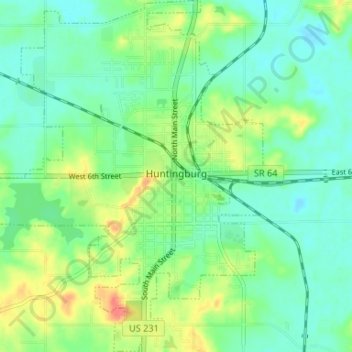
Name: Topografische Karte Huntingburg, Höhe, Relief.
Ort: Huntingburg, Dubois County, Indiana, 47542, United States (38.27276 -86.98886 38.32437 -86.93784)
Durchschnittliche Höhe: 148 m
Minimale Höhe: 130 m
Maximale Höhe: 187 m
Andere topografische Karten
Klicken Sie auf eine Karte, um ihre Topografie, ihre Höhe und ihr Relief anzuzeigen.
Hillham
United States > Indiana > Dubois County
Hillham, Dubois County, Indiana, United States
Durchschnittliche Höhe: 208 m
Celestine
United States > Indiana > Dubois County
Celestine, Dubois County, Indiana, 47580, United States
Durchschnittliche Höhe: 185 m
Jasper
United States > Indiana > Dubois County > Jasper
Jasper, Dubois County, Indiana, 47546, United States
Durchschnittliche Höhe: 150 m
Holland
United States > Indiana > Dubois County > Holland
Holland, Dubois County, Indiana, United States
Durchschnittliche Höhe: 155 m
Jasper
United States > Indiana > Dubois County > Jasper
Jasper, Dubois County, Indiana, United States
Durchschnittliche Höhe: 151 m
Ferdinand
United States > Indiana > Dubois County
Ferdinand, Dubois County, Indiana, 47532, United States
Durchschnittliche Höhe: 162 m