
Topografische Karte Dagupan
Klicken Sie auf die Karte, um die Höhe anzuzeigen.
Über diese Karte
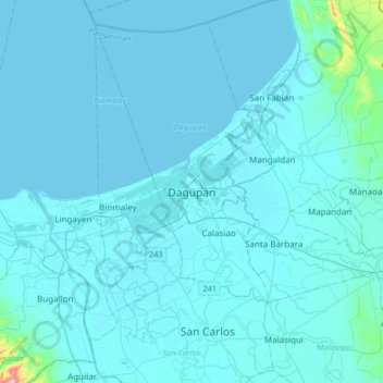
Name: Topografische Karte Dagupan, Höhe, Relief.
Ort: Dagupan, Pangasinan, Ilocos Region, Philippines (15.88302 120.17376 16.20302 120.49376)
Durchschnittliche Höhe: 12 m
Minimale Höhe: -1 m
Maximale Höhe: 319 m
Andere topografische Karten
Klicken Sie auf eine Karte, um ihre Topografie, ihre Höhe und ihr Relief anzuzeigen.
Agno River
The headwaters of Agno River are at the slopes of Mount Data in the Cordillera Mountains at an elevation of 2,090 metres (6,860 ft), where it drains Cretaceous to Paleocene igneous basement rocks, and marine siliciclastic and carbonate rocks. Of its total length, about 90 kilometres (56 mi) runs through…
Durchschnittliche Höhe: 521 m
San Nicolas
During the latter part of the 18th century and the beginning of the 19th century, there was a significant migration of Ilocano families to Pangasinan, driven by factors such as rapid population growth and limited land availability for habitation and cultivation. While Ilocano migration to San Nicolas likely…
Durchschnittliche Höhe: 397 m
Urdaneta
Rainfall is heaviest in August, which is typically the peak of the rainy season, and lightest in January during the dry period. Humidity remains high year-round due to the city’s low elevation and proximity to coastal air masses, contributing to consistently warm and humid conditions. Humidity remains high…
Durchschnittliche Höhe: 29 m
Agno River
The headwaters of Agno River are at the slopes of Mount Data in the Cordillera Mountains at an elevation of 2,090 metres (6,860 ft), where it drains Cretaceous to Paleocene igneous basement rocks, and marine siliciclastic and carbonate rocks. Of its total length, about 90 kilometres (56 mi) runs through…
Durchschnittliche Höhe: 521 m