Geolokalisieren
👉 Easily get elevation data in JSON, GeoTIFF and KML formats using Elevation API
Vielen Dank für die Unterstützung dieser Website ❤️
Spenden

Topografische Karte Feijó

Klicken Sie auf die Karte, um die Höhe anzuzeigen.

👉 Easily get elevation data in JSON, GeoTIFF and KML formats using Elevation API
Vielen Dank für die Unterstützung dieser Website ❤️
Spenden

Über diese Karte

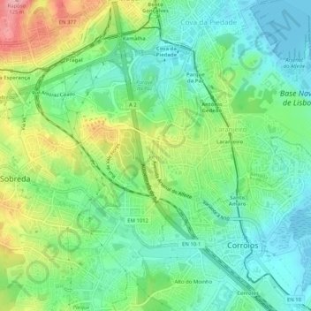
Name: Topografische Karte Feijó, Höhe, Relief.

Ort: Feijó, Almada, Setúbal, 2810-010, Portugal (38.63298 -9.18656 38.67298 -9.14656)

Durchschnittliche Höhe: 41 m

Minimale Höhe: -3 m

Maximale Höhe: 120 m

👉 Easily get elevation data in JSON, GeoTIFF and KML formats using Elevation API
Vielen Dank für die Unterstützung dieser Website ❤️
Spenden

Andere topografische Karten

Klicken Sie auf eine Karte, um ihre Topografie, ihre Höhe und ihr Relief anzuzeigen.

Cova da Piedade

Portugal > Setúbal > Almada

Durchschnittliche Höhe: 34 m

Charneca de Caparica

Portugal > Setúbal > Almada

Durchschnittliche Höhe: 34 m

Sobreda

Portugal > Setúbal > Almada

Durchschnittliche Höhe: 57 m

Caparica

Portugal > Setúbal > Almada

Durchschnittliche Höhe: 59 m

Vielen Dank für die Unterstützung dieser Website ❤️
Spenden

Porto Brandão

Portugal > Setúbal > Almada

Durchschnittliche Höhe: 59 m

Feijó

Portugal > Setúbal > Almada

Durchschnittliche Höhe: 43 m

Laranjeiro

Portugal > Setúbal > Almada

Durchschnittliche Höhe: 24 m

Caparica

Portugal > Setúbal > Almada

Durchschnittliche Höhe: 59 m

Vielen Dank für die Unterstützung dieser Website ❤️
Spenden