
Topografische Karte Mount Desert
Interaktive Karte
Klicken Sie auf die Karte, um die Höhe anzuzeigen.
Über diese Karte
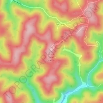
Name: Topografische Karte Mount Desert, Höhe, Relief.
Durchschnittliche Höhe: 408 m
Minimale Höhe: 273 m
Maximale Höhe: 491 m
Andere topografische Karten
Klicken Sie auf eine Karte, um ihre Topografie, ihre Höhe und ihr Relief anzuzeigen.
Grantsville
United States of America > West Virginia > Grantsville
Grantsville, Calhoun County, West Virginia, 26147, United States of America
Durchschnittliche Höhe: 261 m
Seneca Rocks
United States of America > West Virginia
Seneca Rocks, Pendleton County, West Virginia, 26884, United States of America
Durchschnittliche Höhe: 623 m
Kedron
United States of America > West Virginia > Kedron
Kedron, Upshur County, West Virginia, United States of America
Durchschnittliche Höhe: 626 m
Fosterville
United States of America > West Virginia > Fosterville
Fosterville, Boone County, West Virginia, 25181, United States of America
Durchschnittliche Höhe: 351 m
Huntington
United States of America > West Virginia > Huntington
Huntington, Cabell County, West Virginia, United States of America
Durchschnittliche Höhe: 218 m
Lindside
United States of America > West Virginia > Lindside
Lindside, Monroe County, West Virginia, United States of America
Durchschnittliche Höhe: 652 m