
Topografische Karte Somerset
Interaktive Karte
Klicken Sie auf die Karte, um die Höhe anzuzeigen.
Über diese Karte
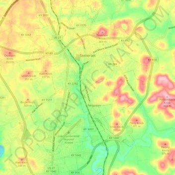
Name: Topografische Karte Somerset, Höhe, Relief.
Ort: Somerset, Pulaski County, Kentucky, 42503, United States (37.03135 -84.64756 37.12006 -84.56484)
Durchschnittliche Höhe: 295 m
Minimale Höhe: 202 m
Maximale Höhe: 398 m
Somerset is located at 37°4′59″N 84°36′34″W / 37.08306°N 84.60944°W / 37.08306; -84.60944 (37.082966, −84.609387), and the downtown (central) part of the city is at an elevation of 974 feet above sea level. The city is located at the eastern end of Kentucky's Mississippian Plateau (or Pennyroyal Plateau); however, the micropolitan area extends eastward into the Appalachian Plateau (or Eastern Kentucky Coalfield), and northward to Kentucky's Outer Bluegrass region. Thus, the area shows variations in landforms and scenery.
Andere topografische Karten
Klicken Sie auf eine Karte, um ihre Topografie, ihre Höhe und ihr Relief anzuzeigen.
Sinking Valley
United States > Kentucky > Pulaski County
Sinking Valley, Pulaski County, Kentucky, United States
Durchschnittliche Höhe: 309 m
Eubank
United States > Kentucky > Pulaski County
Eubank, Pulaski County, Kentucky, United States
Durchschnittliche Höhe: 354 m
Oil Center
United States > Kentucky > Pulaski County
Oil Center, Pulaski County, Kentucky, United States
Durchschnittliche Höhe: 268 m
Burnside
United States > Kentucky > Pulaski County
Burnside, Pulaski County, Kentucky, United States
Durchschnittliche Höhe: 251 m
Science Hill
United States > Kentucky > Pulaski County
Science Hill, Pulaski County, Kentucky, United States
Durchschnittliche Höhe: 327 m
Elrod
United States > Kentucky > Pulaski County > Elrod
Elrod, Pulaski County, Kentucky, United States
Durchschnittliche Höhe: 298 m
Keno
United States > Kentucky > Pulaski County
Keno, Pulaski County, Kentucky, United States
Durchschnittliche Höhe: 308 m