
Topografische Karte Potomac River
Interaktive Karte
Klicken Sie auf die Karte, um die Höhe anzuzeigen.
Über diese Karte
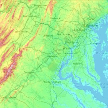
Name: Topografische Karte Potomac River, Höhe, Relief.
Durchschnittliche Höhe: 143 m
Minimale Höhe: -5 m
Maximale Höhe: 1.207 m
Andere topografische Karten
Klicken Sie auf eine Karte, um ihre Topografie, ihre Höhe und ihr Relief anzuzeigen.
Chesapeake Bay
United States of America > Maryland
Chesapeake Bay, Dorchester County, Maryland, United States of America
Durchschnittliche Höhe: 0 m
Upper Potomac River
United States of America > Maryland
Upper Potomac River, Washington County, Maryland, 25434, United States of America
Durchschnittliche Höhe: 220 m
Lower Potomac River
United States of America > Maryland
Lower Potomac River, Charles County, Maryland, 20566, United States of America
Durchschnittliche Höhe: 39 m
Williston Lake
United States of America > Maryland > Williston
Williston Lake, Williston Road, Williams Heights, Williston, Caroline County, Maryland, 21629, United States of America
Durchschnittliche Höhe: 11 m
Auth Village
United States of America > Maryland > Auth Village
Auth Village, Camp Springs, Prince George's County, Maryland, 20746, United States of America
Durchschnittliche Höhe: 77 m
Fairview
United States of America > Maryland > Fairview
Fairview, Burtonsville, Montgomery County, Maryland, 20866, United States of America
Durchschnittliche Höhe: 135 m
East Riverdale
United States of America > Maryland > East Riverdale
East Riverdale, Prince George's County, Maryland, 20737, United States of America
Durchschnittliche Höhe: 36 m
Wood Point
United States of America > Maryland > Wood Point
Wood Point, Washington County, Maryland, 21741, United States of America
Durchschnittliche Höhe: 184 m
Gunpowder
United States of America > Maryland
Gunpowder, Joppatowne, Harford County, Maryland, 21085, United States of America
Durchschnittliche Höhe: 38 m