
Spenden
Topografische Karte Chikkaballapura
Klicken Sie auf die Karte, um die Höhe anzuzeigen.
Spenden
Chikkaballapura
Chikkaballapur has a high elevation located in the center of the Nandi Hills region. "Panchagiri" is a common descriptor of Chikkaballapur as it is surrounded by 5 hills, among which Nandi Hill is the most famous. (the five hills are Nandi Giri, Chandra Giri, Skandagiri, Brahma Giri, and Hema Giri).
Spenden
Über diese Karte
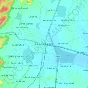
Name: Topografische Karte Chikkaballapura, Höhe, Relief.
Durchschnittliche Höhe: 929 m
Minimale Höhe: 894 m
Maximale Höhe: 1.220 m
Spenden
Andere topografische Karten
Klicken Sie auf eine Karte, um ihre Topografie, ihre Höhe und ihr Relief anzuzeigen.
Nandi Hills State Forest
India > Karnataka > Chikkaballapura taluk > Suddahalli
Durchschnittliche Höhe: 865 m
Nandi Hills State Forest
India > Karnataka > Chikkaballapura taluk > Kanivenarayanapura
Durchschnittliche Höhe: 853 m
Nandi Hills State Forest
India > Karnataka > Chikkaballapura taluk > Kanivenarayanapura
Durchschnittliche Höhe: 853 m