
Topografische Karte Barron River
Klicken Sie auf die Karte, um die Höhe anzuzeigen.
Barron River
The Barron's headwaters start in the Mount Hypipamee National Park near Mount Hypipamee at an elevation of 1,200 metres (3,900 ft). The river then flows north 65 kilometres (40 mi) across the Atherton Tablelands before finally turning east after Mareeba towards Kuranda. After passing under the Kuranda Range Highway's bridge and through Kuranda proper, it descends down the 260-metre (850 ft)-high Barron Falls and reaches the Cairns floodplains near Smithfield. The Dinner Falls are located along the upper Barron River.
Über diese Karte
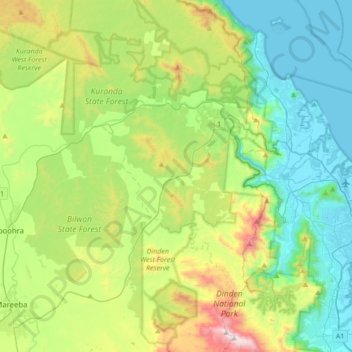
Name: Topografische Karte Barron River, Höhe, Relief.
Durchschnittliche Höhe: 360 m
Minimale Höhe: 0 m
Maximale Höhe: 1.284 m