
Topografische Karte Rendon
Klicken Sie auf die Karte, um die Höhe anzuzeigen.
Über diese Karte
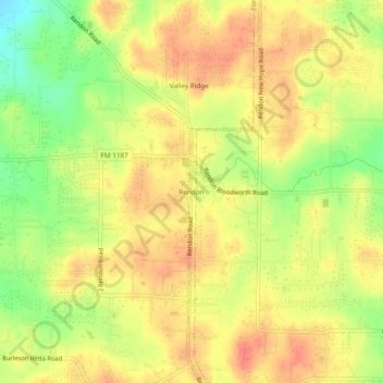
Name: Topografische Karte Rendon, Höhe, Relief.
Ort: Rendon, Fort Worth, Tarrant County, Texas, United States (32.55625 -97.26140 32.59625 -97.22140)
Durchschnittliche Höhe: 221 m
Minimale Höhe: 189 m
Maximale Höhe: 240 m
Andere topografische Karten
Klicken Sie auf eine Karte, um ihre Topografie, ihre Höhe und ihr Relief anzuzeigen.
Sundance Square Plaza
United States > Texas > Tarrant County > Fort Worth
Durchschnittliche Höhe: 178 m
Benbrook Lake
United States > Texas > Tarrant County > Fort Worth
Construction of Benbrook dam began in May 1947, and was practically completed when floodgates were closed and deliberate impoundment was begun in September 1952. The cost to build the lake was $14.5 million ($112 million in 2007 dollars). The rolled-earth embankment is 9,130 feet (2,783 m) in length, including…
Durchschnittliche Höhe: 228 m
Will Rogers Memorial Center
United States > Texas > Tarrant County > Fort Worth
Durchschnittliche Höhe: 181 m