
Topografische Karte Pope County
Interaktive Karte
Klicken Sie auf die Karte, um die Höhe anzuzeigen.
Über diese Karte
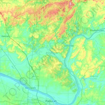
Name: Topografische Karte Pope County, Höhe, Relief.
Ort: Pope County, Illinois, USA (37.06381 -88.70844 37.60270 -88.40911)
Durchschnittliche Höhe: 139 m
Minimale Höhe: 90 m
Maximale Höhe: 324 m
Andere topografische Karten
Klicken Sie auf eine Karte, um ihre Topografie, ihre Höhe und ihr Relief anzuzeigen.
Prestonfield
USA > Illinois > Prestonfield
Prestonfield, Lake County, Illinois, 60074, USA
Durchschnittliche Höhe: 235 m
Montague Island
Montague Island, Rockford, Winnebago County, Illinois, 61104, USA
Durchschnittliche Höhe: 254 m
Garfield Ridge
Garfield Ridge, Chicago, Cook County, Illinois, USA
Durchschnittliche Höhe: 184 m
Mount Carmel
USA > Illinois > Mount Carmel
Mount Carmel, Wabash County, Illinois, USA
Durchschnittliche Höhe: 128 m