Geolokalisieren

Topografische Karte Warminster

Interaktive Karte

Klicken Sie auf die Karte, um die Höhe anzuzeigen.

Warminster

Warminster Town Hall, at the junction of the High Street and Weymouth Street, was designed c. 1837 by Edward Blore at the expense of the 5th Marquess of Bath; the two-storey front elevation is a replica of Longleat, with the addition of a central bellcote, clock and coat of arms.[32] The building was sold by the district council in 1979.[33]

Wikipedia (CC-BY-SA 3.0)

Über diese Karte

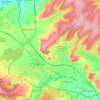
Name: Topografische Karte Warminster, Höhe, Relief.

Ort: Warminster, Wiltshire, England, United Kingdom (51.18948 -2.22830 51.24075 -2.11980)

Durchschnittliche Höhe: 143 m

Minimale Höhe: 70 m

Maximale Höhe: 215 m

Andere topografische Karten

Klicken Sie auf eine Karte, um ihre Topografie, ihre Höhe und ihr Relief anzuzeigen.

Eysey

United Kingdom > England > Wiltshire > Cricklade

Durchschnittliche Höhe: 81 m

Reybridge

United Kingdom > England > Wiltshire > Lacock

Durchschnittliche Höhe: 65 m

Nomansland

United Kingdom > England > Wiltshire

Durchschnittliche Höhe: 68 m

Botley Hill

United Kingdom > England > Wiltshire

Durchschnittliche Höhe: 178 m

Hippenscombe

United Kingdom > England > Wiltshire

Durchschnittliche Höhe: 214 m

Deptford

United Kingdom > England > Wiltshire > Wylye > Deptford

Durchschnittliche Höhe: 110 m

Larkhill

United Kingdom > England > Wiltshire > Larkhill

Durchschnittliche Höhe: 111 m

West Kennett

United Kingdom > England > Wiltshire

Durchschnittliche Höhe: 174 m

Lower Chicksgrove

United Kingdom > England > Wiltshire > Lower Chicksgrove

Durchschnittliche Höhe: 120 m

Jugg's Wood

United Kingdom > England > Wiltshire > Froxfield

Durchschnittliche Höhe: 131 m

Hawkeridge

United Kingdom > England > Wiltshire > Hawkeridge

Durchschnittliche Höhe: 57 m