
Spenden
Topografische Karte Metro Vancouver Regional District
Klicken Sie auf die Karte, um die Höhe anzuzeigen.
Spenden
Über diese Karte
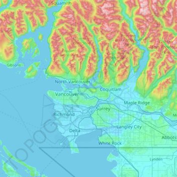
Name: Topografische Karte Metro Vancouver Regional District, Höhe, Relief.
Durchschnittliche Höhe: 343 m
Minimale Höhe: -4 m
Maximale Höhe: 2.149 m
Spenden
Andere topografische Karten
Klicken Sie auf eine Karte, um ihre Topografie, ihre Höhe und ihr Relief anzuzeigen.
Burnaby
Canada > British Columbia > Metro Vancouver Regional District > Burnaby
Burnaby occupies 98.60 square kilometres (38.07 sq mi) and is located at the geographic centre of the Metro Vancouver area and home to the Metro Vancouver regional government in Metrotown. Situated between the city of Vancouver on the west and Port Moody, Coquitlam, and New Westminster on the east, Burnaby is…
Durchschnittliche Höhe: 144 m
Grouse Mountain
Canada > British Columbia > Metro Vancouver Regional District
Grouse Mountain is one of the North Shore Mountains of the Pacific Ranges in the District Municipality of North Vancouver, British Columbia, Canada. With a maximum elevation of over 1,200 m (4,100 feet) at its peak, the mountain is the site of an alpine ski area, Grouse Mountain Resort, which overlooks Greater…
Durchschnittliche Höhe: 968 m
Spenden
Burnaby Mountain
Canada > British Columbia > Metro Vancouver Regional District > Burnaby
Due to its relatively high elevation, snow will often fall on the higher levels of Burnaby Mountain while rain falls in the surrounding cities. Tobogganing is a popular pastime at Centennial Park on winter days with snow.
Durchschnittliche Höhe: 167 m
Surrey
Canada > British Columbia > Metro Vancouver Regional District > Surrey
Durchschnittliche Höhe: 65 m
Kamloops
Canada > British Columbia > Thompson-Nicola Regional District > Kamloops
Durchschnittliche Höhe: 875 m
Stanley Park
Canada > British Columbia > Metro Vancouver Regional District > Vancouver
Durchschnittliche Höhe: 14 m
Spenden
Langley Township
Canada > British Columbia > Metro Vancouver Regional District > Township of Langley > Langley Township
Durchschnittliche Höhe: 37 m
Victoria
Canada > British Columbia > Capital Regional District > Victoria
Durchschnittliche Höhe: 47 m
Whistler
Canada > British Columbia > Squamish-Lillooet Regional District > Whistler Resort Municipality > Whistler
Durchschnittliche Höhe: 996 m
Spenden
Coquitlam
Canada > British Columbia > Metro Vancouver Regional District > Coquitlam
Southwest Coquitlam comprises the original core of the city, with Maillardville and Fraser River industrial sector giving way to the large residential areas of Austin Heights, colloquially referred to as "The Bump" due to its high and flat plateau topography. These older residences, with larger property…
Durchschnittliche Höhe: 230 m
Leonie Lake
Canada > British Columbia > Thompson-Nicola Regional District > Area O (Lower North Thompson)
Durchschnittliche Höhe: 1.107 m
China Creek
Canada > British Columbia > Alberni-Clayoquot Regional District > Area F (Cherry Creek)
Durchschnittliche Höhe: 664 m
Shawnigan Lake
Canada > British Columbia > Cowichan Valley Regional District > Area B (Shawnigan Lake)
Durchschnittliche Höhe: 128 m
Spenden
Nanoose Bay
Canada > British Columbia > Regional District of Nanaimo > Area E (Nanoose Bay)
Durchschnittliche Höhe: 58 m
Fairmont Hot Springs
Canada > British Columbia > Regional District of East Kootenay > Area F (Columbia Lake/Windermere Lake)
Durchschnittliche Höhe: 920 m
Phillips Lake
Canada > British Columbia > Strathcona Regional District > Area C (Discovery Islands/Mainland Inlets)
Durchschnittliche Höhe: 235 m
Greenstone Mountain
Canada > British Columbia > Thompson-Nicola Regional District > Area J (Copper Desert Country)
Durchschnittliche Höhe: 1.624 m
Spenden
Valentine Lake
Canada > British Columbia > Cariboo Regional District > Area G (Lac La Hache/108 Mile Ranch)
Durchschnittliche Höhe: 1.254 m
Magnum Mine
Canada > British Columbia > Northern Rockies Regional Municipality
Durchschnittliche Höhe: 1.096 m
Allen Meadows Lake
Canada > British Columbia > Thompson-Nicola Regional District > Area J (Copper Desert Country)
Durchschnittliche Höhe: 1.214 m
Spenden
Saanich Peninsula
Canada > British Columbia > Capital Regional District > Central Saanich
Durchschnittliche Höhe: 49 m
Hedley
Canada > British Columbia > Regional District of Okanagan-Similkameen > Area G (Upper Similkameen/Hedley)
Durchschnittliche Höhe: 822 m
Kitkatla
Canada > British Columbia > North Coast Regional District > Area C (South Skeena)
Durchschnittliche Höhe: 14 m
Newcastle Ridge
Canada > British Columbia > Regional District of Mount Waddington > Area D (Nimpkish Valley/Cormorant Island)
Durchschnittliche Höhe: 1.047 m
Spenden
Fort Nelson
Canada > British Columbia > Northern Rockies Regional Municipality
Durchschnittliche Höhe: 404 m
Groundbirch
Canada > British Columbia > Peace River Regional District > Area E (Moberly Lake/Sukunka Valley)
Durchschnittliche Höhe: 741 m
Young Lake
Canada > British Columbia > Capital Regional District > Juan de Fuca Electoral Area
Durchschnittliche Höhe: 138 m
Telegraph Creek
Canada > British Columbia > Regional District of Kitimat-Stikine > Area D (Iskut/Big Raven)
Durchschnittliche Höhe: 461 m
Spenden
Alford Point
Canada > British Columbia > North Coast Regional District > Area E (Moresby Island)
Durchschnittliche Höhe: 61 m
Lake O'Hara
Canada > British Columbia > Columbia-Shuswap Regional District > Area A (Kicking Horse/Kinbasket Lake)
Lake O'Hara is a lake at an elevation of 2,020 metres (6,630 ft) in the alpine area of Yoho National Park, in the province of British Columbia, on the western side of the Great Divide with the province of Alberta and Banff National Park to the east. The lake and the valley are accessible through a bus service…
Durchschnittliche Höhe: 2.276 m
Horsefly
Canada > British Columbia > Cariboo Regional District > Area F (Horsefly/Likely/150 Mile House)
Durchschnittliche Höhe: 807 m
Sandal Lake
Canada > British Columbia > Regional District of Kitimat-Stikine > Area A (Nass Valley/Bell Irving)
Durchschnittliche Höhe: 379 m
Spenden
Stanley Glacier
Canada > British Columbia > Columbia-Shuswap Regional District > Area A (Kicking Horse/Kinbasket Lake)
Durchschnittliche Höhe: 2.488 m
Grasmere
Canada > British Columbia > Regional District of East Kootenay > Area B (Lake Koocanusa)
Durchschnittliche Höhe: 1.067 m
Teapot Hill
Canada > British Columbia > Fraser Valley Regional District > Area H (Cultus Lake/Columbia Valley)
Durchschnittliche Höhe: 283 m
Mount Mackenzie
Canada > British Columbia > Columbia-Shuswap Regional District > Area B (Shelter Bay/Mica Creek)
Durchschnittliche Höhe: 1.975 m
Spenden
Beacon Mountain
Canada > British Columbia > Squamish-Lillooet Regional District > Area C (Pemberton Valley/Mount Currie/D'Arcy)
Durchschnittliche Höhe: 1.496 m
Butters Lake
Canada > British Columbia > Regional District of Central Kootenay > Area D (Lardeau Valley/Duncan Lake)
Durchschnittliche Höhe: 2.133 m
Purcell Mountains
Canada > British Columbia > Regional District of East Kootenay > Area G (Forster Creek/Mount Assiniboine)
Durchschnittliche Höhe: 2.710 m
Vallican
Canada > British Columbia > Regional District of Central Kootenay > Area H (The Slocan Valley)
Durchschnittliche Höhe: 821 m
Spenden
Whistler Olympic Park
Canada > British Columbia > Squamish-Lillooet Regional District > Area D (Elaho/Garibaldi)
Durchschnittliche Höhe: 954 m
Raspberry
Canada > British Columbia > Regional District of Central Kootenay > Area J (Lower Arrow/Columbia)
Durchschnittliche Höhe: 651 m
Spences Bridge
Canada > British Columbia > Thompson-Nicola Regional District > Area I (Blue Sky Country)
Spences Bridge's location is mountainous, with higher elevations part of the Interior Plateau. The east side of the Fraser here is part of the Clear Range, a mountainous southwards extension of the Fraser Plateau located in the angle of the Thompson and Fraser Rivers. Arthur Seat lies in that range on the west…
Durchschnittliche Höhe: 496 m
St. Mary Lake
Canada > British Columbia > Regional District of Bulkley-Nechako > Area C (Stuart Lake/Omineca Valley)
Durchschnittliche Höhe: 807 m
Spenden
Abraham Collins' Lookout
Canada > British Columbia > Capital Regional District > North Saanich
Durchschnittliche Höhe: 149 m
Big Sicker Mountain
Canada > British Columbia > Cowichan Valley Regional District > North Cowichan
Durchschnittliche Höhe: 559 m
Abbotsford
Canada > British Columbia > Fraser Valley Regional District > Abbotsford
Durchschnittliche Höhe: 115 m
Silver Peak
Canada > British Columbia > Fraser Valley Regional District > Area B (South Fraser Canyon/Sunshine Valley)
Durchschnittliche Höhe: 1.354 m
Spenden
Mount Vic
Canada > British Columbia > Cariboo Regional District > Area K (East Chilcotin)
Durchschnittliche Höhe: 2.556 m
Rocky Mountains
Canada > British Columbia > Peace River Regional District > Area E (Moberly Lake/Sukunka Valley)
Durchschnittliche Höhe: 1.462 m
Panorama Ridge
Canada > British Columbia > Central Coast Regional District > Area C (Hagensborg/Talchako/Atnarko)
Durchschnittliche Höhe: 1.897 m
Spenden
Quathiaski Cove
Canada > British Columbia > Strathcona Regional District > Area B (Discovery Islands/Mainland Inlets)
Durchschnittliche Höhe: 40 m
Hunters Range
Canada > British Columbia > Columbia-Shuswap Regional District > Area E (Eagle River Valley)
Durchschnittliche Höhe: 904 m
Ship Island
Canada > British Columbia > North Coast Regional District > Area D (Graham Island)
Durchschnittliche Höhe: 4 m
Brûlé Lake
Canada > British Columbia > Regional District of Fraser-Fort George > Area A (Salmon River/Lakes)
Durchschnittliche Höhe: 780 m
Spenden
Mike Lake
Canada > British Columbia > Metro Vancouver Regional District > Maple Ridge
Durchschnittliche Höhe: 297 m
Turner Glacier
Canada > British Columbia > Fraser Valley Regional District > Area C (Sasquatch Country)
Durchschnittliche Höhe: 2.183 m
Lost Peak
Canada > British Columbia > Squamish-Lillooet Regional District > Area B (Cayoosh/Pavilion)
Durchschnittliche Höhe: 2.176 m
Big Creek
Canada > British Columbia > Cariboo Regional District > Area K (East Chilcotin)
Durchschnittliche Höhe: 2.031 m
Spenden
Frosty Mountain
Canada > British Columbia > Regional District of Okanagan-Similkameen > Area H (Manning Park/Tulameen/Siwash)
Durchschnittliche Höhe: 2.010 m
Colinwood Park
Canada > British Columbia > Regional District of Nanaimo > Nanaimo
Durchschnittliche Höhe: 104 m
Ghost Mountain
Canada > British Columbia > Columbia-Shuswap Regional District > Area A (Kicking Horse/Kinbasket Lake)
Durchschnittliche Höhe: 2.542 m
Mission Creek Regional Park
Canada > British Columbia > Regional District of Central Okanagan > Kelowna
Durchschnittliche Höhe: 436 m
Spenden
Coast Mountains
Canada > British Columbia > Central Coast Regional District > Area A (Ocean Falls/Outer Coast)
Durchschnittliche Höhe: 648 m
Black Dome Mountain
Canada > British Columbia > Thompson-Nicola Regional District > Area E (Bonaparte Plateau)
Durchschnittliche Höhe: 1.931 m
Tamihi Rapids
Canada > British Columbia > Fraser Valley Regional District > Area E (Chilliwack River Valley)
Durchschnittliche Höhe: 252 m
Spenden
Delta
Canada > British Columbia > Metro Vancouver Regional District > Delta
Durchschnittliche Höhe: 13 m
Nanoose Bay
Canada > British Columbia > Regional District of Nanaimo > Area E (Nanoose Bay)
Durchschnittliche Höhe: 58 m
Mount Meager
Canada > British Columbia > Squamish-Lillooet Regional District > Area C (Pemberton Valley/Mount Currie/D'Arcy)
Durchschnittliche Höhe: 2.110 m
Hoodoo Mountain
Canada > British Columbia > Regional District of Kitimat-Stikine > Area D (Iskut/Big Raven)
Hoodoo Mountain, sometimes referred to as Hoodoo Volcano, is a potentially active stratovolcano in the Northern Interior of British Columbia, Canada. It is located 25 kilometres (16 miles) northeast of the Alaska–British Columbia border on the north side of the Iskut River opposite of the mouth of the Craig…
Durchschnittliche Höhe: 1.657 m
Spenden
Dolphin Beach
Canada > British Columbia > Regional District of Nanaimo > Area E (Nanoose Bay)
Durchschnittliche Höhe: 32 m
Kondor Lake
Canada > British Columbia > Cariboo Regional District > Area J (West Chilcotin)
Durchschnittliche Höhe: 1.718 m
Jellicoe
Canada > British Columbia > Regional District of Okanagan-Similkameen > Area H (Manning Park/Tulameen/Siwash)
Durchschnittliche Höhe: 1.206 m
Forbidden Plateau
Canada > British Columbia > Comox Valley Regional District > Area C (Puntledge/Black Creek)
Durchschnittliche Höhe: 650 m
Spenden
Koksilah River
Canada > British Columbia > Cowichan Valley Regional District > Area B (Shawnigan Lake)
Durchschnittliche Höhe: 174 m
Rocky Mountains
Canada > British Columbia > Regional District of East Kootenay > Area A (Upper Flathead/Elk Valley)
Durchschnittliche Höhe: 2.159 m
Beaton
Canada > British Columbia > Columbia-Shuswap Regional District > Area B (Shelter Bay/Mica Creek)
Durchschnittliche Höhe: 674 m
Carmi
Canada > British Columbia > Regional District of Kootenay Boundary > Area E (Beaverdell/West Boundary)
Durchschnittliche Höhe: 988 m
Spenden
Mount Meager
Canada > British Columbia > Squamish-Lillooet Regional District > Area C (Pemberton Valley/Mount Currie/D'Arcy)
Durchschnittliche Höhe: 2.110 m
Okanagan Falls
Canada > British Columbia > Regional District of Okanagan-Similkameen > Area D (Skaha East/Okanagan Falls)
Durchschnittliche Höhe: 478 m
Site C Dam
Canada > British Columbia > Peace River Regional District > Area E (Moberly Lake/Sukunka Valley)
Durchschnittliche Höhe: 483 m
Kingsvale
Canada > British Columbia > Thompson-Nicola Regional District > Area N (Beautiful Nicola Valley - South)
Durchschnittliche Höhe: 928 m
Spenden
Fort Fraser
Canada > British Columbia > Regional District of Bulkley-Nechako > Area D (Endako/Fort Fraser)
Durchschnittliche Höhe: 732 m
Spences Bridge
Canada > British Columbia > Thompson-Nicola Regional District > Area I (Blue Sky Country)
Spences Bridge's location is mountainous, with higher elevations part of the Interior Plateau. The east side of the Fraser here is part of the Clear Range, a mountainous southwards extension of the Fraser Plateau located in the angle of the Thompson and Fraser Rivers. Arthur Seat lies in that range on the west…
Durchschnittliche Höhe: 496 m
Comox Glacier
Canada > British Columbia > Alberni-Clayoquot Regional District > Area D (Sproat Lake)
Durchschnittliche Höhe: 1.584 m
Sun Peaks
Canada > British Columbia > Thompson-Nicola Regional District > Sun Peaks Mountain Resort Municipality
Durchschnittliche Höhe: 1.490 m
Spenden
Mystic Mountain
Canada > British Columbia > Columbia-Shuswap Regional District > Area A (Kicking Horse/Kinbasket Lake)
Durchschnittliche Höhe: 2.192 m
Chain Lake
Canada > British Columbia > Regional District of Okanagan-Similkameen > Area H (Manning Park/Tulameen/Siwash)
Durchschnittliche Höhe: 1.165 m
Red Rock
Canada > British Columbia > Regional District of Fraser-Fort George > Area D (Tabor Lake/Stone Creek)
Durchschnittliche Höhe: 651 m
Oyama
Canada > British Columbia > Regional District of Central Okanagan > Lake Country
Durchschnittliche Höhe: 481 m
Spenden
Valley of the Rocks
Canada > British Columbia > Regional District of East Kootenay > Area G (Forster Creek/Mount Assiniboine)
Durchschnittliche Höhe: 2.198 m
Highland Valley
Canada > British Columbia > Thompson-Nicola Regional District > Logan Lake
Durchschnittliche Höhe: 1.190 m
Meziadin Junction
Canada > British Columbia > Regional District of Kitimat-Stikine > Area A (Nass Valley/Bell Irving)
Durchschnittliche Höhe: 345 m
Hagwilget
Canada > British Columbia > Regional District of Kitimat-Stikine > Area B (Suskwa/Kitwanga/Kispiox)
Durchschnittliche Höhe: 337 m
Spenden