
Topografische Karte Gabriola Island
Interaktive Karte
Klicken Sie auf die Karte, um die Höhe anzuzeigen.
Gabriola Island
Gabriola is about 14 kilometres (9 mi) long by 4.2 kilometres (2.6 mi) wide on average with a land area of 57.6 square kilometres (22.2 sq mi). The topography varies from flat sandy beaches at sea level to forested hills rising to 160 metres (525 ft) on Stoney Ridge in the centre of the island.
Über diese Karte
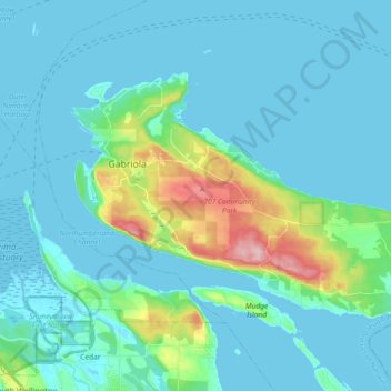
Name: Topografische Karte Gabriola Island, Höhe, Relief.
Durchschnittliche Höhe: 26 m
Minimale Höhe: -2 m
Maximale Höhe: 174 m
Andere topografische Karten
Klicken Sie auf eine Karte, um ihre Topografie, ihre Höhe und ihr Relief anzuzeigen.
Gabriola
Canada > British Columbia > Regional District of Nanaimo > Area B (DeCourcy/Gabriola/Mudge)
Gabriola is about 14 kilometres (9 mi) long by 4.2 kilometres (2.6 mi) wide on average with a land area of 57.6 square kilometres (22.2 sq mi). The topography varies from flat sandy beaches at sea level to forested hills rising to 160 metres (525 ft) on Stoney Ridge in the centre of the island.
Durchschnittliche Höhe: 31 m