
Topografische Karte Middletown
Interaktive Karte
Klicken Sie auf die Karte, um die Höhe anzuzeigen.
Middletown
Middletown is located at 39°26′58″N 75°42′59″W / 39.44944°N 75.71639°W / 39.44944; -75.71639 (39.4495560, –75.7163207) with an elevation of 66 feet (20.1 m).
Über diese Karte
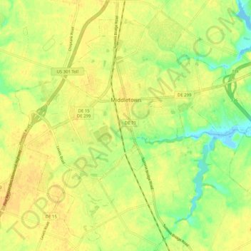
Name: Topografische Karte Middletown, Höhe, Relief.
Ort: Middletown, New Castle County, Delaware, United States (39.40561 -75.76149 39.47761 -75.66007)
Durchschnittliche Höhe: 17 m
Minimale Höhe: -1 m
Maximale Höhe: 25 m
Andere topografische Karten
Klicken Sie auf eine Karte, um ihre Topografie, ihre Höhe und ihr Relief anzuzeigen.
Quaker Hill
United States > Delaware > New Castle County > Hockessin, Delaware
Durchschnittliche Höhe: 94 m
Wilmington
United States > Delaware > New Castle County > Wilmington
On the western side of Market Street, the Piedmont topography is rocky and hilly, rising to a point that marks the watershed between the Brandywine River and the Christina River. This watershed line runs along Delaware Avenue westward from 10th Street and Market Street.
Durchschnittliche Höhe: 43 m
Concord Hills
United States > Delaware > New Castle County > Concord Hills
Durchschnittliche Höhe: 113 m
Runnymeade
United States > Delaware > New Castle County > Hockessin, Delaware > Runnymeade
Durchschnittliche Höhe: 92 m
Tree Top Valley
United States > Delaware > New Castle County > Hockessin, Delaware > Tree Top Valley
Durchschnittliche Höhe: 93 m