
Topografische Karte Middletown
Klicken Sie auf die Karte, um die Höhe anzuzeigen.
Middletown
Middletown is located at 39°26′58″N 75°42′59″W / 39.44944°N 75.71639°W / 39.44944; -75.71639 (39.4495560, –75.7163207) with an elevation of 66 feet (20.1 m).
Über diese Karte
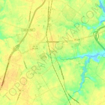
Name: Topografische Karte Middletown, Höhe, Relief.
Ort: Middletown, New Castle County, Delaware, United States (39.40561 -75.76149 39.47761 -75.66007)
Durchschnittliche Höhe: 17 m
Minimale Höhe: -1 m
Maximale Höhe: 25 m
Andere topografische Karten
Klicken Sie auf eine Karte, um ihre Topografie, ihre Höhe und ihr Relief anzuzeigen.
Concord Manor
United States > Delaware > New Castle County > Talleyville
Durchschnittliche Höhe: 108 m
Penn Acres South
United States > Delaware > New Castle County > Wilmington Manor
Durchschnittliche Höhe: 12 m
Carousel Park and Equestrian Center
United States > Delaware > New Castle County > Carousel Knoll
Durchschnittliche Höhe: 56 m
Canby Park Estates
United States > Delaware > New Castle County > Wilmington
Durchschnittliche Höhe: 29 m
Cool Spring Reservoir
United States > Delaware > New Castle County > Wilmington
Durchschnittliche Höhe: 38 m
Old College Historic District
United States > Delaware > New Castle County > Newark > Oakland
Durchschnittliche Höhe: 40 m
Yorklyn
United States > Delaware > New Castle County > Hockessin
Yorklyn is an unincorporated community in northern New Castle County, Delaware, United States. It lies along Delaware Route 82 northwest of the city of Wilmington, the county seat of New Castle County. Its elevation is 174 feet (53 m). It has a post office with the ZIP code 19736.
Durchschnittliche Höhe: 91 m
Alapocas Run State Park
United States > Delaware > New Castle County > Blue Ball
Durchschnittliche Höhe: 80 m
Quaker Hill
United States > Delaware > New Castle County > Hockessin, Delaware
Durchschnittliche Höhe: 94 m
Meeting House Meadows
United States > Delaware > New Castle County > Hockessin
Durchschnittliche Höhe: 95 m
Penn Acres South
United States > Delaware > New Castle County > Wilmington Manor
Durchschnittliche Höhe: 12 m
Wilmington
United States > Delaware > New Castle County > Wilmington
On the western side of Market Street, the Piedmont topography is rocky and hilly, rising to a point that marks the watershed between the Brandywine River and the Christina River. This watershed line runs along Delaware Avenue westward from 10th Street and Market Street.
Durchschnittliche Höhe: 43 m
Runnymeade
United States > Delaware > New Castle County > Hockessin, Delaware > Runnymeade
Durchschnittliche Höhe: 92 m