
Topografische Karte North Carolina
Interaktive Karte
Klicken Sie auf die Karte, um die Höhe anzuzeigen.
Über diese Karte
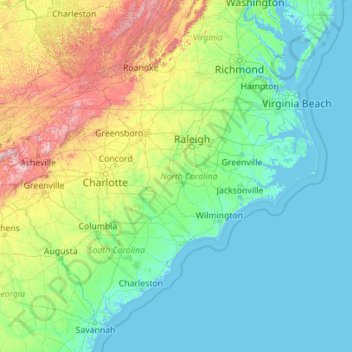
Name: Topografische Karte North Carolina, Höhe, Relief.
Ort: North Carolina, United States (33.75288 -84.32183 36.58816 -75.40012)
Durchschnittliche Höhe: 163 m
Minimale Höhe: -3 m
Maximale Höhe: 1.945 m
North Carolina is defined by a wide range of elevations and landscapes. From west to east, North Carolina's elevation descends from the Appalachian Mountains to the Piedmont and Atlantic coastal plain. North Carolina's Mount Mitchell at 6,684 feet (2,037 m) is the highest point in North America east of the Mississippi River. Most of the state falls in the humid subtropical climate zone; however, the western, mountainous part of the state has a subtropical highland climate.
Andere topografische Karten
Klicken Sie auf eine Karte, um ihre Topografie, ihre Höhe und ihr Relief anzuzeigen.
Albuquerque
United States > New Mexico > Bernalillo County
Albuquerque, Bernalillo County, New Mexico, United States
Durchschnittliche Höhe: 1.688 m
Worcester
United States > Massachusetts > Worcester County
Worcester, Worcester County, Massachusetts, United States
Durchschnittliche Höhe: 186 m
Bonita Springs
United States > Florida > Lee County
Bonita Springs, Lee County, Florida, United States
Durchschnittliche Höhe: 5 m
Annapolis
United States > Maryland > Anne Arundel County
Annapolis, Anne Arundel County, Maryland, United States
Durchschnittliche Höhe: 8 m
Brooklyn
United States > New York > New York
Brooklyn, Kings County, New York, United States
Durchschnittliche Höhe: 9 m
Allegheny County
Allegheny County, Pennsylvania, United States
Durchschnittliche Höhe: 325 m
Hudson River
Hudson River, New Jersey, 12834:12871, United States
Durchschnittliche Höhe: 297 m
Jacksonville
United States > Florida > Duval County
Jacksonville, Duval County, Florida, United States
Durchschnittliche Höhe: 10 m
Montgomery County
Montgomery County, Pennsylvania, United States
Durchschnittliche Höhe: 109 m
Indianapolis
United States > Indiana > Indianapolis
Indianapolis, Marion County, Indiana, 46204, United States
Durchschnittliche Höhe: 241 m
Knoxville
United States > Tennessee > Knox County
Knoxville, Knox County, East Tennessee, Tennessee, United States
Durchschnittliche Höhe: 307 m
Los Angeles
Los Angeles, California, United States
Durchschnittliche Höhe: 241 m
Waltham
United States > Massachusetts > Middlesex County
Waltham, Middlesex County, Massachusetts, United States
Durchschnittliche Höhe: 48 m
Eau Claire County
Eau Claire County, Wisconsin, United States
Durchschnittliche Höhe: 304 m
Bergen County
Bergen County, New Jersey, United States
Durchschnittliche Höhe: 66 m
Oakland County
Oakland County, Michigan, United States
Durchschnittliche Höhe: 282 m
Stamford
United States > Connecticut > Western Connecticut Planning Region
Stamford, Western Connecticut Planning Region, Connecticut, United States
Durchschnittliche Höhe: 48 m
Houston
United States > Texas > Harris County
Houston, Harris County, Texas, United States
Durchschnittliche Höhe: 25 m
Santa Cruz
United States > California > Santa Cruz County
Santa Cruz, Santa Cruz County, California, United States
Durchschnittliche Höhe: 89 m
Texas City
United States > Texas > Galveston County
Texas City, Galveston County, Texas, United States
Durchschnittliche Höhe: 2 m
Yosemite National Park
Yosemite National Park, California, United States
Durchschnittliche Höhe: 2.337 m
Appalachian Mountains
United States > North Carolina > Yancey County
Appalachian Mountains, Yancey County, North Carolina, United States
Durchschnittliche Höhe: 1.463 m
Aurora
United States > Colorado > Adams County
Aurora, Adams County, Colorado, United States
Durchschnittliche Höhe: 1.691 m
Boulder
United States > Colorado > Boulder County
Boulder, Boulder County, Colorado, United States
Durchschnittliche Höhe: 1.785 m