
Topografische Karte Nischni Nowgorod
Interaktive Karte
Klicken Sie auf die Karte, um die Höhe anzuzeigen.
Über diese Karte
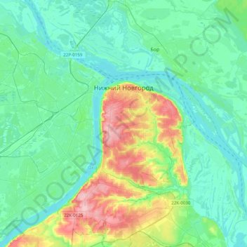
Name: Topografische Karte Nischni Nowgorod, Höhe, Relief.
Durchschnittliche Höhe: 93 m
Minimale Höhe: 59 m
Maximale Höhe: 209 m
Andere topografische Karten
Klicken Sie auf eine Karte, um ihre Topografie, ihre Höhe und ihr Relief anzuzeigen.
Стрелка
Russland > Oblast Nischni Nowgorod > Stadtkreis Nischni Nowgorod > Nischni Nowgorod
Durchschnittliche Höhe: 76 m
Кусаковка
Russland > Oblast Nischni Nowgorod > Stadtkreis Nischni Nowgorod
Durchschnittliche Höhe: 116 m