
Topografische Karte Ann Arbor
Interaktive Karte
Klicken Sie auf die Karte, um die Höhe anzuzeigen.
Ann Arbor
Ann Arbor features a varied topography characterized by rolling hills and valleys shaped by glacial activity. The city is situated along the Huron River, which carves its way through the landscape, creating steep banks and fertile floodplains. Elevations range from approximately 750 feet (230 meters) along the river to over 1,015 feet (309 meters) in the western regions near Maple Road and Pauline Boulevard. This gradual elevation change contributes to the scenic beauty of the area, with higher terrain predominantly found in the west-central and northwestern parts of the city, including the University of Michigan's North Campus. The region's hills and lush valleys are interspersed with agricultural lands, making it a productive area for farming and fruit growing.
Über diese Karte
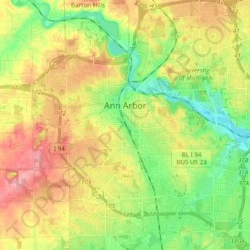
Name: Topografische Karte Ann Arbor, Höhe, Relief.
Ort: Ann Arbor, Washtenaw County, Michigan, United States (42.22267 -83.79957 42.32389 -83.67581)
Durchschnittliche Höhe: 268 m
Minimale Höhe: 223 m
Maximale Höhe: 326 m
Andere topografische Karten
Klicken Sie auf eine Karte, um ihre Topografie, ihre Höhe und ihr Relief anzuzeigen.
Rawsonville
United States > Michigan > Washtenaw County > Ypsilanti Charter Township
Durchschnittliche Höhe: 214 m
Green Lake
United States > Michigan > Washtenaw County > Lyndon Township
Durchschnittliche Höhe: 295 m
Rawsonville
United States > Michigan > Washtenaw County > Ypsilanti Charter Township
Durchschnittliche Höhe: 214 m
Mooreville
United States > Michigan > Washtenaw County > York Charter Township
Durchschnittliche Höhe: 222 m