
Vielen Dank für die Unterstützung dieser Website ❤️
Spenden
Spenden
Topografische Karte Rajamahendravaram
Klicken Sie auf die Karte, um die Höhe anzuzeigen.
Vielen Dank für die Unterstützung dieser Website ❤️
Spenden
Spenden
Rajamahendravaram
Rajahmundry is located at 16°59′N 81°47′E / 16.98°N 81.78°E / 16.98; 81.78. with an average elevation of 14 metres (46 ft). It is geographically located at centre of Godavari Districts.There is paddy, sugarcane and various varieties of flowers cultivation in the area. River Godavari flows through the west of Rajahmundry.
Vielen Dank für die Unterstützung dieser Website ❤️
Spenden
Spenden
Über diese Karte
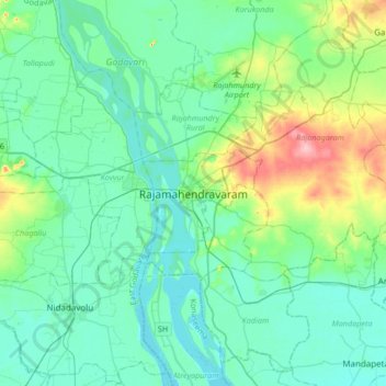
Name: Topografische Karte Rajamahendravaram, Höhe, Relief.
Durchschnittliche Höhe: 29 m
Minimale Höhe: 4 m
Maximale Höhe: 130 m
Vielen Dank für die Unterstützung dieser Website ❤️
Spenden
Spenden