
Topografische Karte Estado Trujillo
Interaktive Karte
Klicken Sie auf die Karte, um die Höhe anzuzeigen.
Über diese Karte
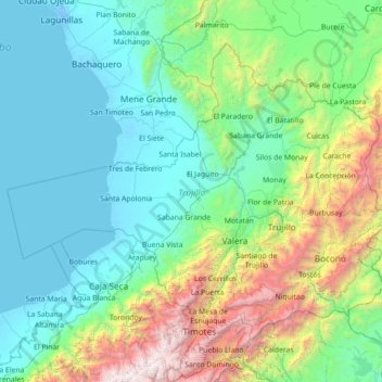
Name: Topografische Karte Estado Trujillo, Höhe, Relief.
Ort: Estado Trujillo, Venezuela (8.95194 -71.45671 10.03975 -70.03446)
Durchschnittliche Höhe: 803 m
Minimale Höhe: -8 m
Maximale Höhe: 4.634 m
Esta iglesia es una de las más grandes y altas del estado Trujillo. Por su gran estructura y su historia esta iglesia es muy visitada por turistas y feligreses. Tanto la iglesia de San Alejo y la iglesia del Carmen, están dedicadas a los patronos de Boconó entre los cuales destaca el glorioso ideólogo Bernardo Aceituno. En la actualidad se está desarrollando una instalación de luces multicolor led en la fachada y torre del Santuario, y también el proyecto para la elevación a Basílica Menor
Andere topografische Karten
Klicken Sie auf eine Karte, um ihre Topografie, ihre Höhe und ihr Relief anzuzeigen.
Isla de Anacoco
Venezuela > Estado Bolívar > Parroquia Dalla Costa
Isla de Anacoco, Parroquia Dalla Costa, Distrito Roscio, Estado Bolívar, Venezuela
Durchschnittliche Höhe: 108 m
Barcelona
Venezuela > Estado Anzoátegui > Municipio Simón Bolívar > Barcelona
Barcelona, Parroquia El Carmen, Municipio Simón Bolívar, Estado Anzoátegui, 6001, Venezuela
Durchschnittliche Höhe: 81 m
Puerto Ordaz
Venezuela > Estado Bolívar > Municipio Caroní
Puerto Ordaz, Ciudad Guayana, Parroquia Unare, Municipio Caroní, Estado Bolívar, 8050, Venezuela
Durchschnittliche Höhe: 73 m
Paso El Caballo
Venezuela > Estado Guárico > Municipio Francisco de Miranda
Paso El Caballo, Parroquia Calabozo, Municipio Francisco de Miranda, Estado Guárico, Venezuela
Durchschnittliche Höhe: 50 m
Boconoíto
Venezuela > Estado Portuguesa > Municipio San Genaro de Boconoíto
Boconoíto, Parroquia Capital Boconoíto, Municipio San Genaro de Boconoíto, Estado Portuguesa, Venezuela
Durchschnittliche Höhe: 203 m
Barcelona
Venezuela > Estado Anzoátegui > Municipio Simón Bolívar
Barcelona, Parroquia San Cristóbal, Municipio Simón Bolívar, Estado Anzoátegui, 6001, Venezuela
Durchschnittliche Höhe: 81 m
Playa Maurica
Venezuela > Estado Anzoátegui > Municipio Simón Bolívar > Barcelona
Playa Maurica, Nueva Barcelona, Barcelona, Parroquia San Cristóbal, Municipio Simón Bolívar, Estado Anzoátegui, 6001, Venezuela
Durchschnittliche Höhe: 2 m
Guanarito
Venezuela > Estado Portuguesa > Municipio Guanarito
Guanarito, Parroquia Capital Guanarito, Municipio Guanarito, Estado Portuguesa, Venezuela
Durchschnittliche Höhe: 89 m
Jají
Venezuela > Municipio Campo Elias
Jají, Parroquia Jají, Municipio Campo Elias, Venezuela
Durchschnittliche Höhe: 1.870 m
Mirador de Caripe
Venezuela > Estado Monagas > Municipio Caripe > Caripe
Mirador de Caripe, R-4, El Banqueado, Caripe, Parroquia Caripe, Municipio Caripe, Estado Monagas, 6210, Venezuela
Durchschnittliche Höhe: 1.135 m
Río Chico
Venezuela > Estado Miranda > Municipio Páez
Río Chico, Parroquia Río Chico, Municipio Páez, Estado Miranda, 1236, Venezuela
Durchschnittliche Höhe: 3 m
Michelena
Venezuela > Estado Táchira > Municipio Michelena
Michelena, Parroquia Michelena, Municipio Michelena, Estado Táchira, Venezuela
Durchschnittliche Höhe: 1.234 m
Parroquia Nuestra Señora del Rosario
Venezuela > Estado Miranda > Municipio Baruta
Parroquia Nuestra Señora del Rosario, Municipio Baruta, Estado Miranda, Venezuela
Durchschnittliche Höhe: 1.047 m
Parroquia Miguel Peña
Venezuela > Estado Carabobo > Municipio Valencia
Parroquia Miguel Peña, Municipio Valencia, Estado Carabobo, Venezuela
Durchschnittliche Höhe: 496 m
Parroquia Nueva Cúa
Venezuela > Estado Miranda > Municipio Urdaneta
Parroquia Nueva Cúa, Municipio Urdaneta, Estado Miranda, Venezuela
Durchschnittliche Höhe: 369 m
Los Teques
Venezuela > Estado Miranda > Municipio Guaicaipuro
Los Teques, Parroquia Los Teques, Municipio Guaicaipuro, Estado Miranda, 1201, Venezuela
Durchschnittliche Höhe: 1.083 m
Guaremal
Venezuela > Estado Miranda > Municipio Guaicaipuro
Guaremal, Parroquia Guaremal, Municipio Guaicaipuro, Estado Miranda, 1201, Venezuela
Durchschnittliche Höhe: 854 m
Puerto Cabello
Venezuela > Estado Carabobo > Municipio Puerto Cabello
Puerto Cabello, Parroquia Juan José Flores, Municipio Puerto Cabello, Estado Carabobo, 2050, Venezuela
Durchschnittliche Höhe: 106 m
UD-324
Venezuela > Estado Bolívar > Municipio Caroní > Puerto Ordaz
UD-324, Villa Betania, Puerto Ordaz, Ciudad Guayana, Parroquia Unare, Municipio Caroní, Estado Bolívar, 8050, Venezuela
Durchschnittliche Höhe: 111 m
Plaza Miranda
Venezuela > Estado Miranda > Municipio Chacao > Caracas
Plaza Miranda, Sector Altamira, Altamira, Caracas, Municipio Chacao, Estado Miranda, 1060, Venezuela
Durchschnittliche Höhe: 956 m
Tinaco
Venezuela > Estado Cojedes > Municipio Tinaco
Tinaco, Parroquia José Laurencio Silva, Municipio Tinaco, Estado Cojedes, 2206, Venezuela
Durchschnittliche Höhe: 245 m
Aguasay
Venezuela > Estado Monagas > Municipio Aguasay
Aguasay, Parroquia Aguasay, Municipio Aguasay, Estado Monagas, Venezuela
Durchschnittliche Höhe: 205 m
Ciudad Orinoco (Soledad)
Venezuela > Estado Anzoátegui > Municipio Independencia
Ciudad Orinoco (Soledad), Parroquia Soledad, Municipio Independencia, Estado Anzoátegui, Venezuela
Durchschnittliche Höhe: 46 m
Caño Manamo
Venezuela > Estado Delta Amacuro > Municipio Tucupita > Tucupita
Caño Manamo, Centro, Tucupita, Parroquia Monseñor Argimiro García, Municipio Tucupita, Estado Delta Amacuro, 6223, Venezuela
Durchschnittliche Höhe: 6 m
Manzanillito
Venezuela > Estado Nueva Esparta > Municipio Macanao
Manzanillito, Parroquia Boca del Río, Municipio Macanao, Estado Nueva Esparta, Venezuela
Durchschnittliche Höhe: 14 m
Parroquia Cachamay
Venezuela > Estado Bolívar > Municipio Caroní
Parroquia Cachamay, Municipio Caroní, Estado Bolívar, Venezuela
Durchschnittliche Höhe: 50 m
Propatria
Venezuela > Distrito Capital > Municipio Libertador > Caracas
Propatria, Caracas, Parroquia Sucre, Municipio Libertador, Distrito Capital, Venezuela
Durchschnittliche Höhe: 1.025 m
Parque Nacional Delta del Orinoco
Venezuela > Estado Delta Amacuro
Parque Nacional Delta del Orinoco, Estado Delta Amacuro, Venezuela
Durchschnittliche Höhe: 4 m
Barquisimeto
Venezuela > Estado Lara > Municipio Iribarren
Barquisimeto, Parroquia Concepción, Municipio Iribarren, Estado Lara, 3001, Venezuela
Durchschnittliche Höhe: 692 m
Área Verde Arborea Corta Protegida de Caracas
Venezuela > Distrito Capital > Municipio Libertador > Caracas
Área Verde Arborea Corta Protegida de Caracas, Caracas, Parroquia Macarao, Municipio Libertador, Distrito Capital, Venezuela
Durchschnittliche Höhe: 1.355 m
Parroquia Santa Ana
Venezuela > Estado Trujillo > Municipio Pampán
Parroquia Santa Ana, Municipio Pampán, Estado Trujillo, Venezuela
Durchschnittliche Höhe: 1.356 m
Topo Puerta Morocha
Venezuela > Estado Miranda > Municipio Guaicaipuro > Boquerón
Topo Puerta Morocha, Boquerón, Parroquia Los Teques, Municipio Guaicaipuro, Estado Miranda, Venezuela
Durchschnittliche Höhe: 855 m
Municipio Los Taques
Municipio Los Taques, Estado Falcón, Venezuela
Durchschnittliche Höhe: 17 m
Ciénaga de Sinamaica
Venezuela > Estado Zulia > Municipio Mara
Ciénaga de Sinamaica, Parroquia Las Parcelas, Municipio Mara, Estado Zulia, Venezuela
Durchschnittliche Höhe: 0 m
Jabillal
Venezuela > Estado Guárico > Municipio Monagas
Jabillal, Parroquia Jabillal, Municipio Monagas, Estado Guárico, Venezuela
Durchschnittliche Höhe: 347 m
Parroquia Vista Al Sol
Venezuela > Estado Bolívar > Municipio Caroní
Parroquia Vista Al Sol, Municipio Caroní, Estado Bolívar, Venezuela
Durchschnittliche Höhe: 60 m
Municipio Mariño
Municipio Mariño, Estado Aragua, Venezuela
Durchschnittliche Höhe: 819 m
Río Capanaparo
Río Capanaparo, Estado Apure, Venezuela
Durchschnittliche Höhe: 92 m