
Topografische Karte Bhavnagar
Interaktive Karte
Klicken Sie auf die Karte, um die Höhe anzuzeigen.
Über diese Karte
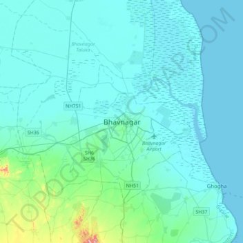
Name: Topografische Karte Bhavnagar, Höhe, Relief.
Durchschnittliche Höhe: 23 m
Minimale Höhe: -1 m
Maximale Höhe: 247 m
Bhavnagar is a coastal city on the eastern coast of Saurashtra, also known as Kathiawar, located at 21°46′N 72°09′E / 21.77°N 72.15°E / 21.77; 72.15. It has an average elevation of 24 metres (78 ft). It occupies an area of 53.3 km2 (20.6 sq mi). The general slope dips towards the northeast at the apex of Gulf of Khambhat. A small non-perennial river named Kansara Nala passes through the outer area of the city.