
Topografische Karte Baguio
Interaktive Karte
Klicken Sie auf die Karte, um die Höhe anzuzeigen.
Über diese Karte
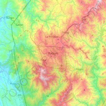
Name: Topografische Karte Baguio, Höhe, Relief.
Durchschnittliche Höhe: 882 m
Minimale Höhe: 24 m
Maximale Höhe: 2.226 m
In 1903, Filipinos, Japanese and Chinese workers were hired to build Kennon Road, the first road directly connecting Baguio with the lowlands of La Union and Pangasinan. Before this, the only road to Benguet was Naguilian Road, and it was largely a horse trail at higher elevations. Camp John Hay was established on October 25, 1903 after President Theodore Roosevelt signed an executive order setting aside land in Benguet for a military reservation for the United States Army. It was named after Roosevelt's Secretary of State, John Milton Hay.
Andere topografische Karten
Klicken Sie auf eine Karte, um ihre Topografie, ihre Höhe und ihr Relief anzuzeigen.
Irisan
Philippines > Benguet > Baguio > Irisan
Irisan, Benguet, Cordillera Administrative Region, 2600, Philippines
Durchschnittliche Höhe: 1.161 m
San Luis Village
Philippines > Benguet > Baguio > San Luis Village
San Luis Village, Baguio, Benguet, 2600, Philippines
Durchschnittliche Höhe: 1.378 m
Padre Burgos
Philippines > Benguet > Baguio > Padre Burgos
Padre Burgos, Baguio, Benguet, 2600, Philippines
Durchschnittliche Höhe: 1.450 m
Happy Hallow
Philippines > Benguet > Baguio
Happy Hallow, Baguio, Benguet, Cordillera Administrative Region, Philippines
Durchschnittliche Höhe: 1.256 m