Geolokalisieren

Topografische Karte Montabone

Interaktive Karte

Klicken Sie auf die Karte, um die Höhe anzuzeigen.

Über diese Karte

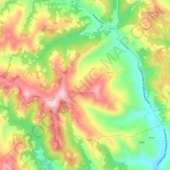
Name: Topografische Karte Montabone, Höhe, Relief.

Ort: Montabone, Asti, Piémont, Italie (44.68602 8.36251 44.71526 8.42055)

Durchschnittliche Höhe: 335 m

Minimale Höhe: 178 m

Maximale Höhe: 497 m

Andere topografische Karten

Klicken Sie auf eine Karte, um ihre Topografie, ihre Höhe und ihr Relief anzuzeigen.

Roccaverano

Italie > Piémont > Asti

Roccaverano, Asti, Piémont, Italie

Durchschnittliche Höhe: 514 m

Cellarengo

Italie > Piémont > Asti

Cellarengo, Asti, Piémont, Italie

Durchschnittliche Höhe: 289 m

Serravalle

Italie > Piémont > Asti > Asti

Serravalle, Asti, Piémont, Italie

Durchschnittliche Höhe: 195 m

Scurzolengo

Italie > Piémont > Asti

Scurzolengo, Asti, Piémont, Italie

Durchschnittliche Höhe: 198 m

Canelli

Italie > Piémont > Asti

Canelli, Asti, Piémont, 14053, Italie

Durchschnittliche Höhe: 248 m

Asti

Italie > Piémont > Asti

Asti, Piémont, 14100, Italie

Durchschnittliche Höhe: 173 m