Geolokalisieren

Topografische Karte Nose Creek

Interaktive Karte

Klicken Sie auf die Karte, um die Höhe anzuzeigen.

Über diese Karte

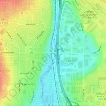
Name: Topografische Karte Nose Creek, Höhe, Relief.

Ort: Nose Creek, Calgary, Alberta, T2K 6H9, Canada (51.11015 -114.04892 51.11097 -114.04880)

Durchschnittliche Höhe: 1.069 m

Minimale Höhe: 1.046 m

Maximale Höhe: 1.100 m

Andere topografische Karten

Klicken Sie auf eine Karte, um ihre Topografie, ihre Höhe und ihr Relief anzuzeigen.

Calgary

Canada > Alberta > Calgary

Durchschnittliche Höhe: 1.106 m

Acadia

Canada > Alberta > Calgary

Durchschnittliche Höhe: 1.049 m

Marlborough

Canada > Alberta > Calgary

Durchschnittliche Höhe: 1.078 m

Acadia

Canada > Alberta > Calgary

Durchschnittliche Höhe: 1.049 m

Southwood

Canada > Alberta > Calgary

Durchschnittliche Höhe: 1.072 m

Silverado

Canada > Alberta > Calgary

Durchschnittliche Höhe: 1.073 m

Eagle Ridge

Canada > Alberta > Calgary

Durchschnittliche Höhe: 1.081 m

Wolf Willow

Canada > Alberta > Calgary

Durchschnittliche Höhe: 1.014 m

Whitehorn

Canada > Alberta > Calgary

Durchschnittliche Höhe: 1.091 m

Beltline

Canada > Alberta > Calgary

Durchschnittliche Höhe: 1.059 m

Abbeydale

Canada > Alberta > Calgary

Durchschnittliche Höhe: 1.067 m

Applewood Park

Canada > Alberta > Calgary

Durchschnittliche Höhe: 1.062 m

Fish Creek Park

Canada > Alberta > Calgary

Durchschnittliche Höhe: 1.044 m

Fish Creek Provincial Park

Canada > Alberta > Calgary

Durchschnittliche Höhe: 1.113 m

Bridlewood

Canada > Alberta > Calgary

Durchschnittliche Höhe: 1.107 m

Bow River

Canada > Alberta > Calgary

Durchschnittliche Höhe: 1.091 m

Glenmore Reservoir

Canada > Alberta > Calgary

Durchschnittliche Höhe: 1.085 m

Yorkville

Canada > Alberta > Calgary

Durchschnittliche Höhe: 1.078 m

Sunalta

Canada > Alberta > Calgary

Durchschnittliche Höhe: 1.071 m