
Topografische Karte Mobile
Interaktive Karte
Klicken Sie auf die Karte, um die Höhe anzuzeigen.
Mobile
Außerdem sind in der Stadt mehrere historische Friedhöfe vorhanden, die nach der Kolonialzeit gegründet wurden und Mobiles Camposanto ersetzt haben, von dem keine Spuren mehr vorhanden sind. Der Church Street Graveyard hat eine Fläche von mehr als 1,6 Hektar und wurde 1819 begründet, auf dem Höhepunkt der Gelbfieberepidemien. Der 1836 gegründete Magnolia Cemetery war die Hauptbegräbnisstätte in Mobile während des 19. Jahrhunderts, etwa 80.000 Bestattungen fanden hier staat. Der Catholic Cemetery entstand 1848 auf Initiative der Erzbistum Mobile. Neben Bestattungen römisch-katholischer Ordensbrüder und -schwestern fanden hier einige weitere historisch bedeutende Personen ihre letzte Ruhestätte. Mobiles jüdische Gemeinde besteht seit den 1820er Jahren und im Stadtgebiet gibt es zwei jüdische Friedhöfe, Ahavas Chesed Cemetery und Sha'arai Shomayim Cemetery.
Über diese Karte
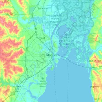
Name: Topografische Karte Mobile, Höhe, Relief.
Durchschnittliche Höhe: 14 m
Minimale Höhe: -2 m
Maximale Höhe: 76 m