Geolokalisieren

Topografische Karte Outeiro de Rei

Interaktive Karte

Klicken Sie auf die Karte, um die Höhe anzuzeigen.

Über diese Karte

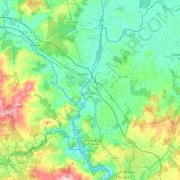
Name: Topografische Karte Outeiro de Rei, Höhe, Relief.

Ort: Outeiro de Rei, Lugo, Galicia, Spain (43.04711 -7.72654 43.16662 -7.49073)

Durchschnittliche Höhe: 443 m

Minimale Höhe: 367 m

Maximale Höhe: 634 m

The town lies on a hill surrounded by the rivers Miño, Rato and Chanca. The difference in altitude between the city centre and the river banks is considerable: the former being at an altitude of 465 meters above sea level, whilst the Miño River Walk is at an altitude of only 364 metres (1,194 feet). The municipality of Lugo is the second largest in Galicia, with 329.78 square kilometres (127.33 sq mi) and 59 parishes. The outline of the city was declared a Biosphere Reserve by UNESCO on 7 November 2002, this being the most important recognition at international level regarding the conservation of landscapes and habitats of this Atlantic European region.

Wikipedia (CC-BY-SA 3.0)

Andere topografische Karten

Klicken Sie auf eine Karte, um ihre Topografie, ihre Höhe und ihr Relief anzuzeigen.

Portomarín

Spain > Galicia > Lugo

Portomarín, Lugo, Galicia, Spain

Durchschnittliche Höhe: 474 m

Outeiro Pequeno

Spain > Galicia > Lugo > Portomarín

Outeiro Pequeno, Vilaxuste, Portomarín, Lugo, Galicia, 27177, Spain

Durchschnittliche Höhe: 530 m

Santa Mariña

Spain > Galicia > Lugo > Outeiro de Rei

Santa Mariña, Outeiro de Rei, Lugo, Galicia, Spain

Durchschnittliche Höhe: 402 m