Geolokalisieren

Topografische Karte Cuenca

Interaktive Karte

Klicken Sie auf die Karte, um die Höhe anzuzeigen.

Über diese Karte

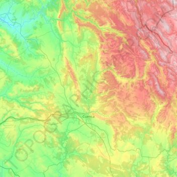
Name: Topografische Karte Cuenca, Höhe, Relief.

Ort: Cuenca, Castile-La Mancha, Spain (39.82644 -2.35502 40.52300 -1.69724)

Durchschnittliche Höhe: 1.124 m

Minimale Höhe: 689 m

Maximale Höhe: 1.915 m

The climate of Cuenca is the typical hot-summer Mediterranean climate of Spain's "Meseta" (inner plateau). Winters are relatively cold, but summers are quite hot during the day with occasional cool nights. Spring and autumn seasons are short, with pleasant temperatures during the day but with rather cold nights due to its altitude from 956 m (3,136 ft) above sea level up to 1,000 m (3,281 ft) in the old town.

Wikipedia (CC-BY-SA 3.0)

Andere topografische Karten

Klicken Sie auf eine Karte, um ihre Topografie, ihre Höhe und ihr Relief anzuzeigen.

Toledo

Spain > Castile-La Mancha

Toledo, Castile-La Mancha, Spain

Durchschnittliche Höhe: 577 m

Tomelloso

Spain > Castile-La Mancha > Tomelloso

Tomelloso, La Mancha, Ciudad Real, Castile-La Mancha, 13700, Spain

Durchschnittliche Höhe: 665 m

La Solana

Spain > Castile-La Mancha > La Solana

La Solana, La Mancha, Ciudad Real, Castile-La Mancha, Spain

Durchschnittliche Höhe: 736 m

Ciudad Real

Spain > Castile-La Mancha

Ciudad Real, Castile-La Mancha, Spain

Durchschnittliche Höhe: 683 m

Tagus

Spain > Castile-La Mancha

Tagus, Toledo, Castile-La Mancha, 28300, Spain

Durchschnittliche Höhe: 622 m

Iberian Peninsula

Spain > Castile-La Mancha > El Carpio de Tajo

Iberian Peninsula, Camino Natural del Tajo - GR 113, El Carpio de Tajo, Toledo, Castile-La Mancha, Spain

Durchschnittliche Höhe: 351 m