
Spenden
Topografische Karte Quilotoa
Klicken Sie auf die Karte, um die Höhe anzuzeigen.
Spenden
Quilotoa
Heute liegt der höchste Punkt auf 3914 m Höhe, Durchmesser der Caldera beträgt 3 km. Der letzte Ausbruch fand möglicherweise im Jahr 1280 statt. Zu dieser Zeit ereignete sich ein gewaltiger Ausbruch (Stufe 6 auf der Skala des Vulkanexplosivitätsindex), dessen Lahar und pyroklastischer Strom den Pazifik erreichten. Seitdem liegt in der Caldera ein bis zu 250 m tiefer Kratersee mit durch Mineralien entstandener grüner Färbung. Am Boden des Sees befinden sich Fumarolen, an der Ostseite des Vulkans gibt es heiße Quellen.
Spenden
Über diese Karte
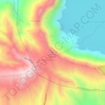
Name: Topografische Karte Quilotoa, Höhe, Relief.
Ort: Quilotoa, Chugchillan, Sigchos, Cotopaxi, 050456, Ecuador (-0.86725 -78.91530 -0.86715 -78.91520)
Durchschnittliche Höhe: 3.721 m
Minimale Höhe: 3.484 m
Maximale Höhe: 3.937 m
Spenden