
Topografische Karte Stadt Landeck
Interaktive Karte
Klicken Sie auf die Karte, um die Höhe anzuzeigen.
Stadt Landeck
Die komplette Liste der Statistik Austria ist in: Topographische Siedlungskennzeichnung nach STAT
Über diese Karte
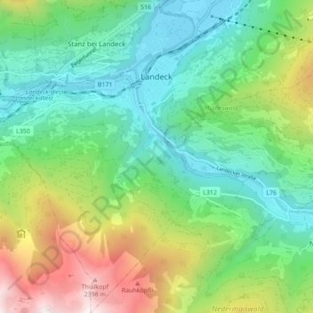
Name: Topografische Karte Stadt Landeck, Höhe, Relief.
Ort: Stadt Landeck, Bezirk Landeck, Tirol, 6500, Österreich (47.09818 10.52642 47.15665 10.60537)
Durchschnittliche Höhe: 1.342 m
Minimale Höhe: 764 m
Maximale Höhe: 2.597 m