Geolokalisieren

Topografische Karte Dundalk

Interaktive Karte

Klicken Sie auf die Karte, um die Höhe anzuzeigen.

Über diese Karte

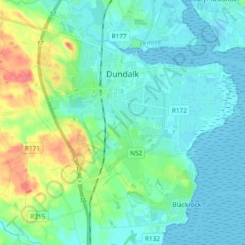
Name: Topografische Karte Dundalk, Höhe, Relief.

Ort: Dundalk, County Louth, Leinster, Irlande (53.95055 -6.44438 54.02793 -6.34154)

Durchschnittliche Höhe: 13 m

Minimale Höhe: -1 m

Maximale Höhe: 59 m

Andere topografische Karten

Klicken Sie auf eine Karte, um ihre Topografie, ihre Höhe und ihr Relief anzuzeigen.

The Borough District of Drogheda

Irlande > County Louth

The Borough District of Drogheda, County Louth, Leinster, Irlande

Durchschnittliche Höhe: 50 m

Dundalk

Irlande > County Louth > Dundalk

Dundalk, The Municipal District of Dundalk, County Louth, Leinster, A91 RC44, Irlande

Durchschnittliche Höhe: 16 m