
Topografische Karte Kailash
Interaktive Karte
Klicken Sie auf die Karte, um die Höhe anzuzeigen.
Kailash
Seine Spitze hat eine außergewöhnlich symmetrische Form und gleicht einem Kristall oder einer Pyramide, die ganzjährig mit Schnee bedeckt ist. Er gilt den Tibetern als heiliger Berg. Seine Höhe wird häufig mit 6714 m angegeben, neueren Quellen zufolge beträgt die Höhe 6638 m.
Über diese Karte
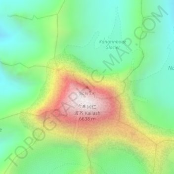
Name: Topografische Karte Kailash, Höhe, Relief.
Durchschnittliche Höhe: 5.748 m
Minimale Höhe: 5.275 m
Maximale Höhe: 6.585 m