
Topografische Karte Maui
Interaktive Karte
Klicken Sie auf die Karte, um die Höhe anzuzeigen.
Über diese Karte
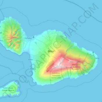
Name: Topografische Karte Maui, Höhe, Relief.
Durchschnittliche Höhe: 232 m
Minimale Höhe: -4 m
Maximale Höhe: 3.044 m
Andere topografische Karten
Klicken Sie auf eine Karte, um ihre Topografie, ihre Höhe und ihr Relief anzuzeigen.
Honolulu
United States of America (Middle Hawai'ian Islands territorial waters) > Hawaii > Honolulu
Honolulu, Honolulu County, Hawaii, United States of America (Middle Hawai'ian Islands territorial waters)
Durchschnittliche Höhe: 88 m
Lānaʻi
United States of America (Middle Hawai'ian Islands territorial waters) > Hawaii
Lānaʻi, Maui County, Hawaii, 96763, United States of America (Middle Hawai'ian Islands territorial waters)
Durchschnittliche Höhe: 162 m
Honolulu County
United States of America (Middle Hawai'ian Islands territorial waters) > Hawaii
Honolulu County, Hawaii, United States of America (Middle Hawai'ian Islands territorial waters)
Durchschnittliche Höhe: 3 m
Moku Manu
United States of America (Middle Hawai'ian Islands territorial waters) > Hawaii > Kailua
Moku Manu, Kailua, Honolulu County, Hawaii, United States of America (Middle Hawai'ian Islands territorial waters)
Durchschnittliche Höhe: 3 m